1970s Maps of Lincoln County, Washington
Explore 6 historic maps of Lincoln County from the 1970s. These maps offer a rare glimpse into what life looked like during the 1970s — showing old roads, neighborhoods, homes, and landmarks that have changed or disappeared over time.
Whether you're researching your family's past, planning a metal detecting trip, or studying how Lincoln County's landscape evolved across the 1970s, these high-resolution maps are a powerful tool for exploring the history of this region.
- Focus on a specific era: All maps on this page are from the 1970s, giving you a focused view of this time period.
- See what’s changed: Compare century-old streets, trails, and buildings to today's modern landscape using overlays and satellite layers.
- Research with precision: Use these maps for genealogy, historical research, land use analysis, or educational projects.
- View, download, or print: Maps are fully viewable online in high resolution, and can be downloaded or printed for your own records.
Start exploring Lincoln County's history through authentic maps from the 1970s. This is your window into the past.
Lincoln County, WA maps
(6)- 1973 Map of Long Lake, 1977 Print
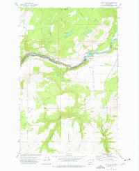
 1973 Long Lake1977 Print · USGSThe Spokane River corridor in the early 1970s reveals a landscape shaped by hydroelectric power and rural industry at the meeting of three counties. Researchers can trace the shoreline of Long Lake and locate local landmarks such as Long Lake Dam, the settlement of Crescent, and Chamokane Falls.
 - 1973 Map of Edwall, 1977 Print
 1973 Edwall1977 Print · USGSEdwall and the surrounding wheat country of Lincoln County are captured here in the early 1970s as the rail-centered agricultural economy thrived. Genealogists and local historians can trace family-named sites such as Hanning Butte and locate the Pleasant Valley Cem near Wheeler Corner.
 - 1973 Map of Reardan West, 1977 Print
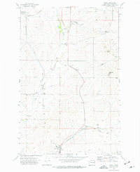
 1973 Reardan West1977 Print · USGSReardan and the surrounding Lincoln County highlands are captured here in the early seventies as the railroad economy defined the local landscape. Genealogists and historians can locate the Pleasant View Cem, the Queen Pit mine, and family-named landmarks like Laupp Lake.
 - 1973 Map of Reardan East, 1977 Print
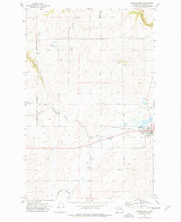
 1973 Reardan East1977 Print · USGSThe eastern reaches of Reardan in the early 1970s reveal a landscape defined by the Burlington Northern railroad and high plateau agriculture. Trace local history through landmarks like the Spring Creek Cem, Grange Hall, and Grain Elevators.
 - 1973 Map of Little Falls, 1977 Print
 1973 Little Falls1977 Print · USGSThe Spokane River canyon and the hydroelectric infrastructure of the 1970s define this borderland between Lincoln and Stevens counties. Researchers can locate the Little Falls settlement and Plant I, or trace the rugged drainages of Tamarack Canyon and Spring Creek Canyon.
 - 1973 Map of Waukon, 1977 Print
 1973 Waukon1977 Print · USGSThe rural borderlands of Lincoln and Spokane counties come into focus during the early 1970s, showing a landscape shaped by dryland farming and rail transport. Researchers can locate the Waukon Grain Elevator, trace the Old Railroad Grade, and find local landmarks like the Grange Hall.
End of results
Showing maps 1-6 of 6
Top cities of Lincoln County
- Davenport historical maps
- Odessa historical maps
- Wilbur historical maps
- Reardan historical maps
- Sprague historical maps
- Harrington historical maps
See more
Frequently asked questions
- What are the different types of historical maps available for Lincoln County?
- What is the oldest map of Lincoln County?
- Where can I purchase historical maps of Lincoln County for my home or office?
- Where can I download high-res historical maps of Lincoln County?
- Are there historical topographic maps available for Lincoln County?
- Is there historical aerial imagery available for Lincoln County?
- Where are historical maps of Lincoln County sourced from?