1970s Maps of Grant County, Washington
Explore 4 historic maps of Grant County from the 1970s. These maps offer a rare glimpse into what life looked like during the 1970s — showing old roads, neighborhoods, homes, and landmarks that have changed or disappeared over time.
Whether you're researching your family's past, planning a metal detecting trip, or studying how Grant County's landscape evolved across the 1970s, these high-resolution maps are a powerful tool for exploring the history of this region.
- Focus on a specific era: All maps on this page are from the 1970s, giving you a focused view of this time period.
- See what’s changed: Compare century-old streets, trails, and buildings to today's modern landscape using overlays and satellite layers.
- Research with precision: Use these maps for genealogy, historical research, land use analysis, or educational projects.
- View, download, or print: Maps are fully viewable online in high resolution, and can be downloaded or printed for your own records.
Start exploring Grant County's history through authentic maps from the 1970s. This is your window into the past.
Grant County, WA maps
(4)- 1970 Map of Hatton NW, 1973 Print
 1970 Hatton NW1973 Print · USGSThe high desert of the Adams and Grant county line is captured here in the early 1970s, during the era of major irrigation development. You can trace the path of the Chicago Milwaukee St Paul and Pacific railroad and the massive Lind Coulee Siphon No 1 as they cross Lind Coulee.
 - 1975 Map of Wenatchee, 1977 Print
 1975 Wenatchee1977 Print · USGSCentral Washington in the mid-seventies shows a landscape of deep mountain valleys and bustling river towns. Trace the industrial and agricultural backbone of the region along the Yakima River and Columbia River, from the mining history of Roslyn to the rail hubs at Cle Elum and Appleyard.
 - 1977 Map of Electric City, 1980 Print
 1977 Electric City1980 Print · USGSThe engineering landscape of the Columbia Basin comes into sharp focus in the late 1970s through this orthophotograph. Researchers can trace the development of Electric City and Grand Coulee or locate landmarks like Eagle Rock.
 - 1979 Map of Priest Rapids
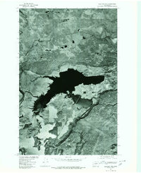
 1979 Priest Rapids1979 Print · USGSThe Columbia River basin in the late seventies reveals a landscape shaped by massive federal projects and rail expansion. Trace the Hanford Works perimeter, the Priest Rapids Dam, and the early growth of Royal City and Othello.2 unique versions available
End of results
Showing maps 1-4 of 4
Top cities of Grant County
- Moses Lake historical maps
- Ephrata historical maps
- Quincy historical maps
- Mattawa historical maps
- Warden historical maps
- Royal City historical maps
See more
Frequently asked questions
- What are the different types of historical maps available for Grant County?
- What is the oldest map of Grant County?
- Where can I purchase historical maps of Grant County for my home or office?
- Where can I download high-res historical maps of Grant County?
- Are there historical topographic maps available for Grant County?
- Is there historical aerial imagery available for Grant County?
- Where are historical maps of Grant County sourced from?