1950s Maps of Fairmont, Washington
Explore 2 historic maps of Fairmont from the 1950s. These maps offer a rare glimpse into what life looked like during the 1950s — showing old roads, neighborhoods, homes, and landmarks that have changed or disappeared over time.
Whether you're researching your family's past, planning a metal detecting trip, or studying how Fairmont's landscape evolved across the 1950s, these high-resolution maps are a powerful tool for exploring the history of this region.
- Focus on a specific era: All maps on this page are from the 1950s, giving you a focused view of this time period.
- See what’s changed: Compare century-old streets, trails, and buildings to today's modern landscape using overlays and satellite layers.
- Research with precision: Use these maps for genealogy, historical research, land use analysis, or educational projects.
- View, download, or print: Maps are fully viewable online in high resolution, and can be downloaded or printed for your own records.
Start exploring Fairmont's history through authentic maps from the 1950s. This is your window into the past.
Fairmont, WA maps
(2)- 1953 Map of Center, 1955 Print
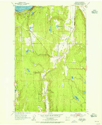 1953 Center1955 Print · USGSThe rural Jefferson County landscape comes alive in the early fifties, showing the interplay of rail and road near the Olympic Peninsula coast. Genealogists and local historians can trace family locations near the Dabob School, the small settlement of Center, and the rail junction at Discovery Junction.3 unique versions available
 - 1958 Map of Seattle, 1966 Print
 1958 Seattle1966 Print · USGSThe Puget Sound region in the mid-fifties showcases a balance of urban growth and Olympic wilderness. Trace the industrial waterfronts of Tacoma, old naval facilities like Keyport Naval Res, and mountain peaks like Mount Constance.3 unique versions available
End of results
Showing maps 1-2 of 2
Top cities near Fairmont
- Poulsbo historical maps
- Port Townsend historical maps
- Sequim historical maps
- Port Hadlock historical maps
- Port Ludlow historical maps
- Coupeville historical maps
See more
Frequently asked questions
- What are the different types of historical maps available for Fairmont?
- What is the oldest map of Fairmont?
- Where can I purchase historical maps of Fairmont for my home or office?
- Where can I download high-res historical maps of Fairmont?
- Are there historical topographic maps available for Fairmont?
- Is there historical aerial imagery available for Fairmont?
- Where are historical maps of Fairmont sourced from?