1900s (20th Century) Maps of Teanaway, Washington
Explore 6 historic maps of Teanaway from the 1900s (20th Century). These maps offer a rare glimpse into what life looked like during the 1900s — showing old roads, neighborhoods, homes, and landmarks that have changed or disappeared over time.
Whether you're researching your family's past, planning a metal detecting trip, or studying how Teanaway's landscape evolved across the 1900s, these high-resolution maps are a powerful tool for exploring the history of this region.
- Focus on a specific era: All maps on this page are from the 1900s, giving you a focused view of this time period.
- See what’s changed: Compare century-old streets, trails, and buildings to today's modern landscape using overlays and satellite layers.
- Research with precision: Use these maps for genealogy, historical research, land use analysis, or educational projects.
- View, download, or print: Maps are fully viewable online in high resolution, and can be downloaded or printed for your own records.
Start exploring Teanaway's history through authentic maps from the 1900s. This is your window into the past.
Teanaway, WA maps
(6)- 1902 Map of Mount Stuart, 1908 Print
 1902 Mount Stuart1908 Print · USGSThe Kittitas Valley and Wenatchee Mountains are shown here during the height of the early twentieth-century rail and mining era. Researchers can trace the industrial landscape through the Roslyn Branch and mountain camps like Liberty and Blewett.5 unique versions available
 - 1957 Map of Wenatchee, 1973 Print
 1957 Wenatchee1973 Print · USGSThe northern Cascades and Columbia River valley appear here in the mid-fifties, showing the region's critical rail and transit corridors. Researchers can trace the routes of the Great Northern RR and Milwaukee Road through settlements like Skykomish, Baring, and Dryden.2 unique versions available
 - 1958 Map of Cle Elum, 1960 Print
 1958 Cle Elum1960 Print · USGSKittitas County coal and rail hubs come alive in this mid-century survey of the Yakima River corridor. Local historians can trace the operations of No 5 Mine, locate old cemeteries near Roslyn, and follow the competing tracks of the Northern Pacific and Milwaukee Road.3 unique versions available
 - 1975 Map of Wenatchee, 1977 Print
 1975 Wenatchee1977 Print · USGSCentral Washington in the mid-seventies shows a landscape of deep mountain valleys and bustling river towns. Trace the industrial and agricultural backbone of the region along the Yakima River and Columbia River, from the mining history of Roslyn to the rail hubs at Cle Elum and Appleyard.
 - 1985 Map of Teanaway
 1985 Teanaway1985 Print · USGSThe Yakima River valley was a bustling transport corridor in the mid-eighties, defined by rail lines and river junctions. You can trace the path of the Burlington Northern through settlements like Bristol and explore landmarks like Indian John Hill and Swauk Prairie.2 unique versions available
 - 1989 Map of Teanaway
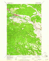
 1989 Teanaway1989 Print · USGSKittitas County high country is shown in detail during the late 1980s, centered on the complex drainage system of the Teanaway River. Researchers can locate the historical Casland (Site) and trace the paths of the Middle Fork Teanaway River and West Fork Teanaway River through the timber of Wenatchee National Forest.
End of results
Showing maps 1-6 of 6
Top cities near Teanaway
Frequently asked questions
- What are the different types of historical maps available for Teanaway?
- What is the oldest map of Teanaway?
- Where can I purchase historical maps of Teanaway for my home or office?
- Where can I download high-res historical maps of Teanaway?
- Are there historical topographic maps available for Teanaway?
- Is there historical aerial imagery available for Teanaway?
- Where are historical maps of Teanaway sourced from?