1970s Maps of Original Bingen, Bingen
Explore 2 historic maps of Original Bingen from the 1970s. These maps offer a rare glimpse into what life looked like during the 1970s — showing old roads, neighborhoods, homes, and landmarks that have changed or disappeared over time.
Whether you're researching your family's past, planning a metal detecting trip, or studying how Original Bingen's landscape evolved across the 1970s, these high-resolution maps are a powerful tool for exploring the history of this region.
- Focus on a specific era: All maps on this page are from the 1970s, giving you a focused view of this time period.
- See what’s changed: Compare century-old streets, trails, and buildings to today's modern landscape using overlays and satellite layers.
- Research with precision: Use these maps for genealogy, historical research, land use analysis, or educational projects.
- View, download, or print: Maps are fully viewable online in high resolution, and can be downloaded or printed for your own records.
Start exploring Original Bingen's history through authentic maps from the 1970s. This is your window into the past.
Original Bingen, Bingen maps
(2)- 1975 Map of White Salmon, 1980 Print
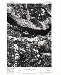 1975 White Salmon1980 Print · USGSThe mid-1970s landscape of the Columbia River Gorge is captured here through detailed aerial photography. Genealogists and local historians can trace the street grids and rural boundaries of White Salmon, Bingen, and Mosier as they appeared decades ago.
 - 1978 Map of White Salmon
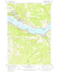 1978 White Salmon1978 Print · USGSThe Columbia River Gorge in the late seventies reveals a bustling transportation corridor shared by Washington and Oregon. Researchers can trace the rail lines of the Northern Burlington, locate family plots at the IOOF Cem, or explore the old layout of White Salmon and Mosier.
End of results
Showing maps 1-2 of 2
Frequently asked questions
- What are the different types of historical maps available for Original Bingen?
- What is the oldest map of Original Bingen?
- Where can I purchase historical maps of Original Bingen for my home or office?
- Where can I download high-res historical maps of Original Bingen?
- Are there historical topographic maps available for Original Bingen?
- Is there historical aerial imagery available for Original Bingen?
- Where are historical maps of Original Bingen sourced from?