Old Maps of Wahkiacus, Washington for Hiking & Exploration
Hike through history with 8 historic maps of Wahkiacus. Explore old trails, ghost towns, and forgotten backroads — perfect for outdoor adventurers and local explorers.
- Rediscover forgotten places: Map out old mining camps, roads, and footpaths that no longer exist on modern maps.
- Layer with modern tools: Combine with LiDAR or satellite views to plan hikes through historical terrain.
- Made for exploration: Popular among hikers, overlanders, and local history lovers.
Use these maps to find adventure and explore the hidden past of Wahkiacus.
Wahkiacus, WA maps
(8)- 1934 Map of The Dalles
 1934 The Dalles1934 Print · USGSThe Columbia River Gorge in the early thirties reveals a complex network of rapids and river engineering before the completion of major modern dams. Local historians can trace early school districts like Threemile Sch and family landmarks such as Clancy Ranch or Petersburg.4 unique versions available
 - 1953 Map of The Dalles, 1965 Print
 1953 The Dalles1965 Print · USGSThe Columbia River Gorge at mid-century shows a region being transformed by massive hydroelectric dams and a growing highway network. Researchers can trace the development of The Dalles Dam, locate the Maryhill Museum, and find old rail stops in Rufus, Wishram, and Arlington.3 unique versions available
 - 1956 Map of The Dalles
 1956 The Dalles1956 Print · USGSThe Columbia River Gorge and the high Cascades are captured in the mid-1950s, showing a vital corridor of rail and road. Researchers can trace the original path of The Old Oregon Trail or locate historical landmarks like the Maryhill Museum and Mount Hood.
 - 1957 Map of The Dalles
 1957 The Dalles1957 Print · USGSThe Columbia River Gorge and the high plateaus of the mid-1950s come alive on this detailed survey of northern Oregon and southern Washington. Researchers can trace the path of the Oregon Trail and The Old Barlow Road alongside river towns like The Dalles and Wishram.
 - 1957 Map of Klickitat, 1959 Print
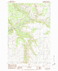
 1957 Klickitat1959 Print · USGSThe river canyon around Klickitat was a busy corridor of timber and rail activity in the 1950s. Researchers can locate specialized sites like Woodruff Mill, the tiny settlement of Wahiacus, and the historic Spokane Portland and Seattle Railroad line.2 unique versions available
 - 1982 Map of Hood River, 1983 Print
 1982 Hood River1983 Print · USGSThe Columbia River Gorge in the early eighties shows a landscape shaped by massive hydroelectric projects and deep-rooted timber communities. Researchers can trace the rail-and-river network through Cascade Locks and The Dalles Dam, or explore the terrain of Gifford Pinchot National Forest.
 - 1983 Map of Wahkiacus
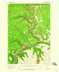
 1983 Wahkiacus1983 Print · USGSThe Klickitat River canyon and its high plateau prairies are captured here in the early 1980s. Local researchers can trace the confluence near Wahkiacus and identify early land features like The Tepee, Maddock Springs, and the deep cut of Swale Canyon.
 - 2023 Map of Wahkiacus, 2023 Print
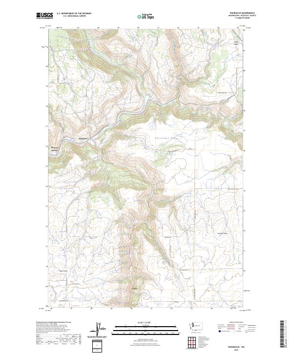 2023 Wahkiacus2023 Print · USGSKlickitat County's river valleys and high prairies come alive in this contemporary survey of the Pacific Northwest landscape. Researchers can trace family-named routes like Finn Ridge Rd and explore the winding Klickitat State Park Trl near Wahkiacus.
End of results
Showing maps 1-8 of 8
Top cities near Wahkiacus
Frequently asked questions
- What are the different types of historical maps available for Wahkiacus?
- What is the oldest map of Wahkiacus?
- Where can I purchase historical maps of Wahkiacus for my home or office?
- Where can I download high-res historical maps of Wahkiacus?
- Are there historical topographic maps available for Wahkiacus?
- Is there historical aerial imagery available for Wahkiacus?
- Where are historical maps of Wahkiacus sourced from?