Old Maps of Morton, Washington
Explore 14 old maps of Morton, spanning from 1937 to today. These high-resolution historic maps reveal how streets, neighborhoods, landmarks, and natural features evolved over time — perfect for genealogy, metal detecting, research, and local history exploration.
What you can do with these maps:
- See how Morton changed over time: Compare historical maps to modern-day views to trace roads, homesites, rail lines & more.
- View detailed metadata: Each map includes creators, publishers, year, scale, and archive source.
- Overlay maps with satellite & LiDAR: Visualize the past alongside modern tools to explore terrain & human change.
- Trusted historical sources: Maps sourced from the USGS, Library of Congress, and other archives.
- Access maps your way: View online, download high-res files, or order prints for personal or research use.
Start exploring old maps of Morton to uncover forgotten places, hidden landmarks, and the deep history beneath your feet.
Morton, WA maps
(14)- 1937 Map of Eatonville
 1937 Eatonville1937 Print · USGSThe timber and mining corridors of Pierce and Lewis Counties are captured here in the mid-1930s. Genealogists and historians can trace the early footprints of Eatonville, locate the Ladd Mine, and follow the path of the Chicago Milwaukee St Paul and Pacific RR.3 unique versions available
 - 1953 Map of Hoquiam
 1953 Hoquiam1953 Print · USGSSouthwest Washington in the early fifties shows a landscape shaped by timber, rail, and river commerce from the coast to the Cascades. Genealogists and historians can trace the development of timber towns like Ryderwood and the industrial hubs of Hoquiam and Kelso.2 unique versions available
 - 1957 Map of Hoquiam
 1957 Hoquiam1957 Print · USGSCoastal timber ports and inland rail hubs define Southwest Washington during the late fifties. Genealogists can trace early twentieth-century settlements like Bordeaux, Tono, and Cosmopolis alongside the expanding tracks of the Northern Pacific.
 - 1957 Map of Morton, 1959 Print
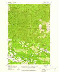 1957 Morton1959 Print · USGSLewis County timber and river life are captured here in the late fifties, from the valley floor to the high peaks. Genealogists and researchers can trace the original locations of Riffe and Swofford or locate the Logging RR serving Morton.3 unique versions available
 - 1958 Map of Hoquiam, 1969 Print
 1958 Hoquiam1969 Print · USGSSouthwest Washington and the Columbia River estuary appear here in the mid-century, before major landscape shifts. Researchers can trace the rail lines of the Northern Pacific, locate the Fort Henness Site, or explore the Naselle Air Force Station.2 unique versions available
 - 1962 Map of Hoquiam
 1962 Hoquiam1962 Print · USGSSouthwest Washington in the late fifties is defined by the bustling timber ports of Hoquiam and the rail-linked commerce of the interior valleys. Genealogists and historians can trace the early footprints of settlements like Raymond and Pe Ell, or locate family sites at Grand Mound Cem and Odd Fellows Cem.
 - 1980 Map of Centralia
 1980 Centralia1980 Print · USGSThe rail and river corridors of southwestern Washington are captured here in the late twentieth century, showing the region's transition from resource extraction to managed forest land. Researchers can trace the industrial footprint of the Stoker Mine, the rails of the Union Pacific, and the early development of Centralia and Chehalis.
 - 1987 Map of Morton
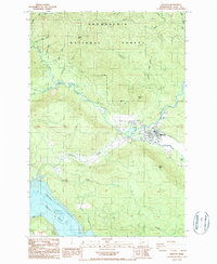 1987 Morton1987 Print · USGSMorton and the surrounding Lewis County timberlands are captured here in the late eighties, showing the town at the junction of the mountain rivers. Researchers can locate local landmarks like Strom Field, the cemetery, and the original extent of Riffe Lake.2 unique versions available
 - 1998 Map of Morton, 2003 Print
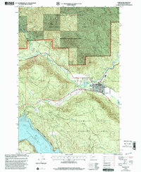 1998 Morton2003 Print · USGSMorton and the surrounding Lewis County timberlands are captured here during the late nineties, showing a landscape defined by forest management and river valleys. Genealogists and local historians can locate Strom Field, the local Cem, and the winding banks of the Tilton River.
 - 2011 Map of Morton, 2011 Print
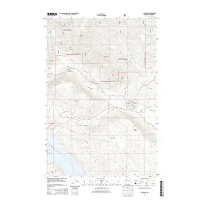
 2011 Morton2011 Print · USGSCovers Morton, including Lewis County, United States, and other nearby areas
 - 2013 Map of Morton, 2013 Print
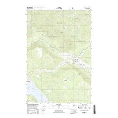
 2013 Morton2013 Print · USGSCovers Morton, including Lewis County, United States, and other nearby areas
 - 2017 Map of Morton, 2017 Print
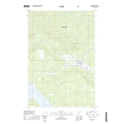
 2017 Morton2017 Print · USGSCovers Morton, including Lewis County, United States, and other nearby areas
 - 2020 Map of Morton, 2020 Print
 2020 Morton2020 Print · USGSCovers Morton, including Lewis County, United States, and other nearby areas
 - 2023 Map of Morton, 2023 Print
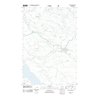
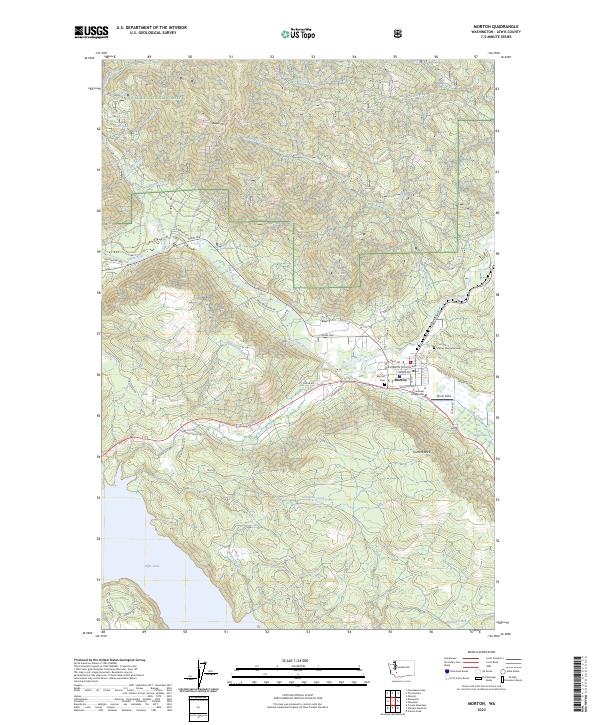 2023 Morton2023 Print · USGSMorton and its surrounding timberlands are documented here in the early twenty-first century, showing the town's position along the Tilton River. Local researchers can trace family landmarks at Stiltner Memorial Cemetery and locate sites like Strom Field or the northern waters of Riffe Lake.
End of results
Showing maps 1-14 of 14
Top cities near Morton
Frequently asked questions
- What are the different types of historical maps available for Morton?
- What is the oldest map of Morton?
- Where can I purchase historical maps of Morton for my home or office?
- Where can I download high-res historical maps of Morton?
- Are there historical topographic maps available for Morton?
- Is there historical aerial imagery available for Morton?
- Where are historical maps of Morton sourced from?