1980s Maps of Nulls Crossing, Washington
Explore 2 historic maps of Nulls Crossing from the 1980s. These maps offer a rare glimpse into what life looked like during the 1980s — showing old roads, neighborhoods, homes, and landmarks that have changed or disappeared over time.
Whether you're researching your family's past, planning a metal detecting trip, or studying how Nulls Crossing's landscape evolved across the 1980s, these high-resolution maps are a powerful tool for exploring the history of this region.
- Focus on a specific era: All maps on this page are from the 1980s, giving you a focused view of this time period.
- See what’s changed: Compare century-old streets, trails, and buildings to today's modern landscape using overlays and satellite layers.
- Research with precision: Use these maps for genealogy, historical research, land use analysis, or educational projects.
- View, download, or print: Maps are fully viewable online in high resolution, and can be downloaded or printed for your own records.
Start exploring Nulls Crossing's history through authentic maps from the 1980s. This is your window into the past.
Nulls Crossing, WA maps
(2)- 1980 Map of Centralia
 1980 Centralia1980 Print · USGSThe rail and river corridors of southwestern Washington are captured here in the late twentieth century, showing the region's transition from resource extraction to managed forest land. Researchers can trace the industrial footprint of the Stoker Mine, the rails of the Union Pacific, and the early development of Centralia and Chehalis.
 - 1984 Map of Logan Hill, 1985 Print
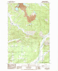 1984 Logan Hill1985 Print · USGSLewis County in the mid-1980s shows a landscape balancing large industrial footprints with deep-rooted rural communities. Researchers can trace historic locations like Mendota and Nulls Crossing or locate the Logan Hill Grange near the coal-rich Open Pit Mine.
End of results
Showing maps 1-2 of 2
Top cities near Nulls Crossing
- Centralia historical maps
- Yelm historical maps
- Chehalis historical maps
- Grand Mound historical maps
- Rainier historical maps
- Napavine historical maps
See more
Frequently asked questions
- What are the different types of historical maps available for Nulls Crossing?
- What is the oldest map of Nulls Crossing?
- Where can I purchase historical maps of Nulls Crossing for my home or office?
- Where can I download high-res historical maps of Nulls Crossing?
- Are there historical topographic maps available for Nulls Crossing?
- Is there historical aerial imagery available for Nulls Crossing?
- Where are historical maps of Nulls Crossing sourced from?