1900s (20th Century) Maps of Packwood, Washington
Explore 9 historic maps of Packwood from the 1900s (20th Century). These maps offer a rare glimpse into what life looked like during the 1900s — showing old roads, neighborhoods, homes, and landmarks that have changed or disappeared over time.
Whether you're researching your family's past, planning a metal detecting trip, or studying how Packwood's landscape evolved across the 1900s, these high-resolution maps are a powerful tool for exploring the history of this region.
- Focus on a specific era: All maps on this page are from the 1900s, giving you a focused view of this time period.
- See what’s changed: Compare century-old streets, trails, and buildings to today's modern landscape using overlays and satellite layers.
- Research with precision: Use these maps for genealogy, historical research, land use analysis, or educational projects.
- View, download, or print: Maps are fully viewable online in high resolution, and can be downloaded or printed for your own records.
Start exploring Packwood's history through authentic maps from the 1900s. This is your window into the past.
Packwood, WA maps
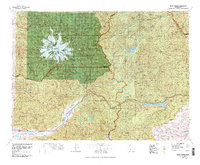
(9)- 1924 Map of Mt Rainier
 1924 Mt Rainier1924 Print · USGSLewis and Pierce counties are shown during the mid-twenties, when the timber economy and the National Forest system were establishing their regional footprint. Genealogists and researchers can locate early rural schools like Cline School and Cora School or trace the network of forest outposts like Packwood Ranger Sta.6 unique versions available
 - 1928 Map of Mt Rainier
 1928 Mt Rainier1928 Print · USGSThe Washington Cascades in the late 1920s reveal a landscape of glaciated peaks and emerging river valley communities. Trace early mountaineering and park history at Longmire, or locate family-named landmarks like Schooley and the Cora School near the Cowlitz River.6 unique versions available
 - 1950 Map of Yakima, 1951 Print
 1950 Yakima1951 Print · USGSThe Yakima Valley and the towering Cascades meet in this mid-century survey of South Central Washington. Genealogists and local historians can trace the irrigation-era growth of Yakima, the historic Fort Simcoe outpost, and the White Swan Mission on the Yakima Indian Reservation.
 - 1958 Map of Yakima, 1964 Print
 1958 Yakima1964 Print · USGSThe Yakima Valley in the late fifties shows a landscape of mountain peaks and irrigated plains at the height of its rail-era development. Researchers can trace the lineage of early settlements through sites like Fort Simcoe, the Wenas Cemetery, and the Yakima Indian Agency School.3 unique versions available
 - 1961 Map of Yakima
 1961 Yakima1961 Print · USGSCentral Washington thrived in the mid-century as an agricultural powerhouse defined by the Yakima River. Trace local roots through Medicine Valley School, Fort Simcoe, and the rail lines of the Northern Pacific RR.
 - 1962 Map of Packwood, 1964 Print
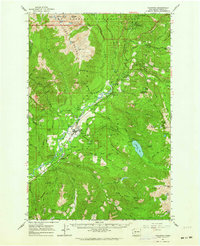 1962 Packwood1964 Print · USGSThe Cowlitz River valley in the early sixties is captured here as a landscape of mountain lookouts and hydroelectric progress. You can trace the Aqueduct toward Packwood, locate the Cemetery, or find remote sites like Huntington Berry Patch and Ohanapecosh Hot Springs.
 - 1978 Map of Mount Rainier
 1978 Mount Rainier1978 Print · USGSThe high Cascades and the Yakima backcountry are shown in detail during the late seventies, centered on the glacial peaks and river valleys. Researchers can trace the development of Packwood and Goose Prairie or locate landmarks like the Packwood Landing Strip and Rimrock Lake.2 unique versions available
 - 1989 Map of Packwood
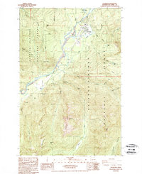 1989 Packwood1989 Print · USGSThe mountain community of Packwood is captured in the late eighties as it sits deep within the Gifford Pinchot National Forest. Researchers can trace the local infrastructure of the era, from the Landing Strip and Ranger Station to the high-country waters of Snyder Lake and Bevin Lake.
 - 1994 Map of Packwood, 1996 Print
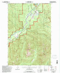 1994 Packwood1996 Print · USGSPackwood and the high Cascades are shown in the mid-nineties as the region balanced forestry with growing recreation. Researchers can trace forest access roads and landmarks like the Landing Strip, Snyder Lake, and the winding Cowlitz River.
End of results
Showing maps 1-9 of 9
Frequently asked questions
- What are the different types of historical maps available for Packwood?
- What is the oldest map of Packwood?
- Where can I purchase historical maps of Packwood for my home or office?
- Where can I download high-res historical maps of Packwood?
- Are there historical topographic maps available for Packwood?
- Is there historical aerial imagery available for Packwood?
- Where are historical maps of Packwood sourced from?