1980s Maps of Salkum, Washington
Explore 2 historic maps of Salkum from the 1980s. These maps offer a rare glimpse into what life looked like during the 1980s — showing old roads, neighborhoods, homes, and landmarks that have changed or disappeared over time.
Whether you're researching your family's past, planning a metal detecting trip, or studying how Salkum's landscape evolved across the 1980s, these high-resolution maps are a powerful tool for exploring the history of this region.
- Focus on a specific era: All maps on this page are from the 1980s, giving you a focused view of this time period.
- See what’s changed: Compare century-old streets, trails, and buildings to today's modern landscape using overlays and satellite layers.
- Research with precision: Use these maps for genealogy, historical research, land use analysis, or educational projects.
- View, download, or print: Maps are fully viewable online in high resolution, and can be downloaded or printed for your own records.
Start exploring Salkum's history through authentic maps from the 1980s. This is your window into the past.
Salkum, WA maps
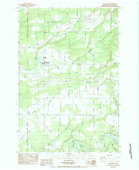
(2)- 1980 Map of Centralia
 1980 Centralia1980 Print · USGSThe rail and river corridors of southwestern Washington are captured here in the late twentieth century, showing the region's transition from resource extraction to managed forest land. Researchers can trace the industrial footprint of the Stoker Mine, the rails of the Union Pacific, and the early development of Centralia and Chehalis.
 - 1984 Map of Onalaska
 1984 Onalaska1984 Print · USGSThe rural timber and farming landscape of Lewis County is captured in the mid-1980s, centered on the mill town of Onalaska. Local researchers can trace family lands along Beck Road, visit Alpha Cemetery, or follow the banks of the Cowlitz River.2 unique versions available
End of results
Showing maps 1-2 of 2
Top cities near Salkum
Frequently asked questions
- What are the different types of historical maps available for Salkum?
- What is the oldest map of Salkum?
- Where can I purchase historical maps of Salkum for my home or office?
- Where can I download high-res historical maps of Salkum?
- Are there historical topographic maps available for Salkum?
- Is there historical aerial imagery available for Salkum?
- Where are historical maps of Salkum sourced from?