1900s (20th Century) Maps of Reardan, Washington
Explore 7 historic maps of Reardan from the 1900s (20th Century). These maps offer a rare glimpse into what life looked like during the 1900s — showing old roads, neighborhoods, homes, and landmarks that have changed or disappeared over time.
Whether you're researching your family's past, planning a metal detecting trip, or studying how Reardan's landscape evolved across the 1900s, these high-resolution maps are a powerful tool for exploring the history of this region.
- Focus on a specific era: All maps on this page are from the 1900s, giving you a focused view of this time period.
- See what’s changed: Compare century-old streets, trails, and buildings to today's modern landscape using overlays and satellite layers.
- Research with precision: Use these maps for genealogy, historical research, land use analysis, or educational projects.
- View, download, or print: Maps are fully viewable online in high resolution, and can be downloaded or printed for your own records.
Start exploring Reardan's history through authentic maps from the 1900s. This is your window into the past.
Reardan, WA maps
(7)- 1945 Map of Reardan
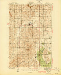 1945 Reardan1945 Print · USGSThe Lincoln County plateau in the mid-forties was a vital crossroads of the Great Northern and Northern Pacific railroads. Genealogists can locate family landmarks like District School No 1, Pleasant View Cem, and the high point of Hanning Butte.2 unique versions available
 - 1953 Map of Reardan, 1954 Print
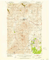 1953 Reardan1954 Print · USGSThe Lincoln County wheat country near the Spokane border is captured here during the early fifties as the region's rural social life thrived. Researchers can trace the rail-and-road network connecting Reardan and Edwall, finding local landmarks like the Pleasant View Cem and West Deep Creek Grange.2 unique versions available
 - 1955 Map of Spokane, 1965 Print
 1955 Spokane1965 Print · USGSInland Empire life in the fifties and sixties centers on the growth of Spokane and the heavy mining industry of northern Idaho. Trace mid-century landmarks like Fairchild Air Force Base, the Bunker Hill Mine, and early campuses such as Gonzaga University.2 unique versions available
 - 1958 Map of Spokane
 1958 Spokane1958 Print · USGSThe Inland Empire is shown at a mid-century peak of industrial and military activity, from the rail hubs of Spokane to the deep silver mines of northern Idaho. Researchers can trace the sprawling rail lines of the Union Pacific RR or locate landmarks like Fairchild Air Force Base and the Bunker Hill Smelter & Mine.
 - 1973 Map of Reardan West, 1977 Print
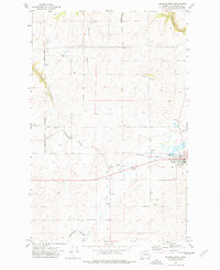 1973 Reardan West1977 Print · USGSReardan and the surrounding Lincoln County highlands are captured here in the early seventies as the railroad economy defined the local landscape. Genealogists and historians can locate the Pleasant View Cem, the Queen Pit mine, and family-named landmarks like Laupp Lake.
 - 1973 Map of Reardan East, 1977 Print
 1973 Reardan East1977 Print · USGSThe eastern reaches of Reardan in the early 1970s reveal a landscape defined by the Burlington Northern railroad and high plateau agriculture. Trace local history through landmarks like the Spring Creek Cem, Grange Hall, and Grain Elevators.
 - 1987 Map of Spokane
 1987 Spokane1987 Print · USGSGreater Spokane and its surrounding prairies are captured in the late 1980s as the region solidified its role as a regional hub. Researchers can trace family sites near Medical Lake, military life at Fairchild Air Force Base, and rural settlements like Peone and Chattaroy.
End of results
Showing maps 1-7 of 7
Top cities near Reardan
Frequently asked questions
- What are the different types of historical maps available for Reardan?
- What is the oldest map of Reardan?
- Where can I purchase historical maps of Reardan for my home or office?
- Where can I download high-res historical maps of Reardan?
- Are there historical topographic maps available for Reardan?
- Is there historical aerial imagery available for Reardan?
- Where are historical maps of Reardan sourced from?