1960s Maps of Ione, Washington
Explore 3 historic maps of Ione from the 1960s. These maps offer a rare glimpse into what life looked like during the 1960s — showing old roads, neighborhoods, homes, and landmarks that have changed or disappeared over time.
Whether you're researching your family's past, planning a metal detecting trip, or studying how Ione's landscape evolved across the 1960s, these high-resolution maps are a powerful tool for exploring the history of this region.
- Focus on a specific era: All maps on this page are from the 1960s, giving you a focused view of this time period.
- See what’s changed: Compare century-old streets, trails, and buildings to today's modern landscape using overlays and satellite layers.
- Research with precision: Use these maps for genealogy, historical research, land use analysis, or educational projects.
- View, download, or print: Maps are fully viewable online in high resolution, and can be downloaded or printed for your own records.
Start exploring Ione's history through authentic maps from the 1960s. This is your window into the past.
Ione, WA maps
(3)- 1963 Map of Sandpoint
 1963 Sandpoint1963 Print · USGSNorthern Idaho and eastern Washington are shown in the early sixties as a high-country network of timber, mining, and rail. Genealogists and historians can trace the Great Northern line through Metaline Falls, Bonners Ferry, and past the Finch Mine.
 - 1967 Map of Ione, 1971 Print
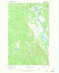 1967 Ione1971 Print · USGSThe Pend Oreille River valley in the late sixties shows a landscape defined by timber, rail, and water. Genealogists and historians can locate the Riverside Cem near Ione or trace the Milwaukee Road railroad through Tiger.4 unique versions available
 - 1967 Map of Metaline, 1971 Print
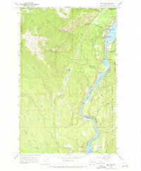 1967 Metaline1971 Print · USGSThe Pend Oreille River valley in the late 1960s reveals a landscape defined by mining, rail transport, and forestry. Researchers can trace the local mining footprint at the Oriole Mine or locate family sites near Perkins Cem and Selkirk High Sch.3 unique versions available
End of results
Showing maps 1-3 of 3
Top cities near Ione
Frequently asked questions
- What are the different types of historical maps available for Ione?
- What is the oldest map of Ione?
- Where can I purchase historical maps of Ione for my home or office?
- Where can I download high-res historical maps of Ione?
- Are there historical topographic maps available for Ione?
- Is there historical aerial imagery available for Ione?
- Where are historical maps of Ione sourced from?