1900s (20th Century) Maps of West Sound, Washington
Explore 12 historic maps of West Sound from the 1900s (20th Century). These maps offer a rare glimpse into what life looked like during the 1900s — showing old roads, neighborhoods, homes, and landmarks that have changed or disappeared over time.
Whether you're researching your family's past, planning a metal detecting trip, or studying how West Sound's landscape evolved across the 1900s, these high-resolution maps are a powerful tool for exploring the history of this region.
- Focus on a specific era: All maps on this page are from the 1900s, giving you a focused view of this time period.
- See what’s changed: Compare century-old streets, trails, and buildings to today's modern landscape using overlays and satellite layers.
- Research with precision: Use these maps for genealogy, historical research, land use analysis, or educational projects.
- View, download, or print: Maps are fully viewable online in high resolution, and can be downloaded or printed for your own records.
Start exploring West Sound's history through authentic maps from the 1900s. This is your window into the past.
West Sound, WA maps
- 1943 Map of Orcas Island
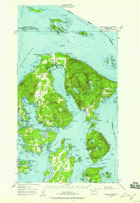
 1943 Orcas Island1943 Print · USGSThe San Juan Islands are captured in the early 1940s, showing a maritime landscape of ferry routes and isolated coastal hamlets. Genealogists and historians can trace local landmarks like Buckhorn Lodge, the Port Stanley Sch, and the CCC Camp in Moran State Park.2 unique versions available
 - 1957 Map of Orcas Island, 1959 Print
 1957 Orcas Island1959 Print · USGSThe San Juan Islands are shown here in the late fifties, a time when coastal settlements and island retreats defined the archipelago. Genealogists and historians can trace old community centers like Griswold, Doe Bay, and the early layout of Moran State Park.2 unique versions available
 - 1957 Map of Victoria, 1960 Print
 1957 Victoria1960 Print · USGSThe San Juan Islands and the North Cascades coastline are shown in detail during the late fifties, a period of significant military and industrial presence. Researchers can trace historic rail lines like the Great Northern or locate sites such as the Whidbey Island Naval Air Sta and Friday Harbor.4 unique versions available
 - 1975 Map of Bellingham, 1977 Print
 1975 Bellingham1977 Print · USGSNorthwest Washington in the mid-seventies is captured here, from the Canadian border at Blaine to the San Juan Islands. Researchers can trace tribal lands on the Lummi Indian Reservation, find rural settlements like Cokedale, or follow the Burlington Northern rail lines.
 - 1977 Map of Eastsound, 1978 Print
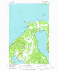 1977 Eastsound1978 Print · USGSOrcas Island in the late seventies is a landscape of protected parks and coastal settlements. Genealogists and island historians can locate the Woodlawn Cem, Orcas Island Sch, and the grounds of Camp Orkila.2 unique versions available
 - 1997 Map of Eastsound, 2003 Print
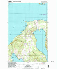 1997 Eastsound2003 Print · USGSOrcas Island in the late twentieth century remains a landscape of deep fjords and island communities. Trace the development of Eastsound and Rosario, or locate heritage sites like the Crow Valley School Museum and Woodlawn Cem.
End of results
Showing maps 1-6
Top cities near West Sound
Frequently asked questions
- What are the different types of historical maps available for West Sound?
- What is the oldest map of West Sound?
- Where can I purchase historical maps of West Sound for my home or office?
- Where can I download high-res historical maps of West Sound?
- Are there historical topographic maps available for West Sound?
- Is there historical aerial imagery available for West Sound?
- Where are historical maps of West Sound sourced from?