1900s (20th Century) Maps of Guemes, Washington
Explore 6 historic maps of Guemes from the 1900s (20th Century). These maps offer a rare glimpse into what life looked like during the 1900s — showing old roads, neighborhoods, homes, and landmarks that have changed or disappeared over time.
Whether you're researching your family's past, planning a metal detecting trip, or studying how Guemes's landscape evolved across the 1900s, these high-resolution maps are a powerful tool for exploring the history of this region.
- Focus on a specific era: All maps on this page are from the 1900s, giving you a focused view of this time period.
- See what’s changed: Compare century-old streets, trails, and buildings to today's modern landscape using overlays and satellite layers.
- Research with precision: Use these maps for genealogy, historical research, land use analysis, or educational projects.
- View, download, or print: Maps are fully viewable online in high resolution, and can be downloaded or printed for your own records.
Start exploring Guemes's history through authentic maps from the 1900s. This is your window into the past.
Guemes, WA maps
(6)- 1943 Map of Anacortes
 1943 Anacortes1943 Print · USGSThe San Juan Islands and Skagit coastline appear here in the early 1940s, during an era of remote island schoolhouses and ferry reliance. Genealogists can locate family landmarks like Eden Cem and Guemes Sch, or trace the waterfront of Anacortes and South Bellingham.
 - 1951 Map of Anacortes, 1953 Print
 1951 Anacortes1953 Print · USGSThe northern Puget Sound islands and the city of Anacortes are captured here in the early fifties during a period of steady coastal growth. Researchers can locate vanished landmarks and family roots at Eden Cem, Sinclair Sch, and the Lummi Indian Reservation.2 unique versions available
 - 1957 Map of Victoria, 1960 Print
 1957 Victoria1960 Print · USGSThe San Juan Islands and the North Cascades coastline are shown in detail during the late fifties, a period of significant military and industrial presence. Researchers can trace historic rail lines like the Great Northern or locate sites such as the Whidbey Island Naval Air Sta and Friday Harbor.4 unique versions available
 - 1973 Map of Anacortes North, 1977 Print
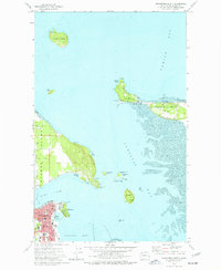 1973 Anacortes North1977 Print · USGSCoastal Skagit County appears in the early 1970s as a landscape of interconnected islands, bays, and growing maritime infrastructure. Genealogists and local historians can trace the roads of Guemes Island, find Eden Cem, and explore the northern reaches of Anacortes near Cap Sante.3 unique versions available
 - 1975 Map of Bellingham, 1977 Print
 1975 Bellingham1977 Print · USGSNorthwest Washington in the mid-seventies is captured here, from the Canadian border at Blaine to the San Juan Islands. Researchers can trace tribal lands on the Lummi Indian Reservation, find rural settlements like Cokedale, or follow the Burlington Northern rail lines.
 - 1998 Map of Anacortes North, 2003 Print
 1998 Anacortes North2003 Print · USGSThe northern waters of the Skagit coast come into focus in the late nineties, documenting the maritime community where the Salish Sea inlets meet. Trace family history and coastal landmarks from the Eden Cem on Guemes Island to the W T Preston Museum in Anacortes.
End of results
Showing maps 1-6 of 6
Top cities near Guemes
- Bellingham historical maps
- Oak Harbor historical maps
- Anacortes historical maps
- La Conner historical maps
Frequently asked questions
- What are the different types of historical maps available for Guemes?
- What is the oldest map of Guemes?
- Where can I purchase historical maps of Guemes for my home or office?
- Where can I download high-res historical maps of Guemes?
- Are there historical topographic maps available for Guemes?
- Is there historical aerial imagery available for Guemes?
- Where are historical maps of Guemes sourced from?