1950s Maps of Sedro-Woolley, Washington
Explore 6 historic maps of Sedro-Woolley from the 1950s. These maps offer a rare glimpse into what life looked like during the 1950s — showing old roads, neighborhoods, homes, and landmarks that have changed or disappeared over time.
Whether you're researching your family's past, planning a metal detecting trip, or studying how Sedro-Woolley's landscape evolved across the 1950s, these high-resolution maps are a powerful tool for exploring the history of this region.
- Focus on a specific era: All maps on this page are from the 1950s, giving you a focused view of this time period.
- See what’s changed: Compare century-old streets, trails, and buildings to today's modern landscape using overlays and satellite layers.
- Research with precision: Use these maps for genealogy, historical research, land use analysis, or educational projects.
- View, download, or print: Maps are fully viewable online in high resolution, and can be downloaded or printed for your own records.
Start exploring Sedro-Woolley's history through authentic maps from the 1950s. This is your window into the past.
Sedro-Woolley, WA maps
(6)- 1951 Map of Wickersham, 1953 Print
 1951 Wickersham1953 Print · USGSSkagit County in the early fifties shows a landscape of river-valley industry and timber outposts along the Skagit River. Genealogists and historians can locate the Northern State Hospital, trace the Cokedale Mine, and find rural centers like Samish School.3 unique versions available
 - 1952 Map of Alger, 1954 Print
 1952 Alger1954 Print · USGSSkagit County in the early fifties shows a landscape defined by riverside settlements and rural agriculture. You can trace early community life through the Silver Run Grange, locate the Belfast Sch (Aban'd), and find the State Salmon Hatchery along Friday Creek.4 unique versions available
 - 1954 Map of Samish Lake, 1960 Print
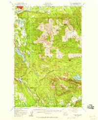
 1954 Samish Lake1960 Print · USGSCoastal Skagit and Whatcom Counties are captured here in the mid-fifties as rural settlements like Garden of Eden and Blue Canyon thrived alongside the growing college town of Bellingham. Genealogists can trace family landmarks like Belfast Sch, the Silver Run Grange Hall, and the Pierson Sch.
 - 1956 Map of Clear Lake, 1958 Print
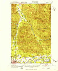
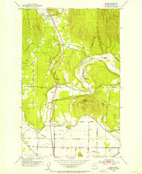
 1956 Clear Lake1958 Print · USGSSkagit County's timber and rail corridor is captured here in the mid-fifties, from the banks of the Skagit River to the peaks of Cultus Mtn. Genealogists and historians can trace old community footprints in Sedro-Woolley, the rail-side village of McMurray, and the Old Railroad Grade near Lake Cavanaugh.3 unique versions available
 - 1956 Map of Mount Vernon, 1958 Print
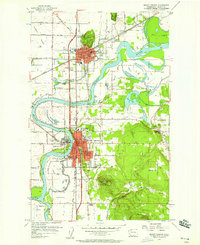 1956 Mount Vernon1958 Print · USGSSkagit County in the mid-fifties is a landscape of river-driven commerce and growing valley towns. Genealogists and historians can trace old school districts like Westview School, find the Meadow Grange, and locate vanished river crossings near Skagit City.6 unique versions available
 - 1957 Map of Victoria, 1960 Print
 1957 Victoria1960 Print · USGSThe San Juan Islands and the North Cascades coastline are shown in detail during the late fifties, a period of significant military and industrial presence. Researchers can trace historic rail lines like the Great Northern or locate sites such as the Whidbey Island Naval Air Sta and Friday Harbor.4 unique versions available
End of results
Showing maps 1-6 of 6
Top cities near Sedro-Woolley
Frequently asked questions
- What are the different types of historical maps available for Sedro-Woolley?
- What is the oldest map of Sedro-Woolley?
- Where can I purchase historical maps of Sedro-Woolley for my home or office?
- Where can I download high-res historical maps of Sedro-Woolley?
- Are there historical topographic maps available for Sedro-Woolley?
- Is there historical aerial imagery available for Sedro-Woolley?
- Where are historical maps of Sedro-Woolley sourced from?