Old Maps of Everett, Washington
Explore 29 old maps of Everett, spanning from 1895 to today. These high-resolution historic maps reveal how streets, neighborhoods, landmarks, and natural features evolved over time — perfect for genealogy, metal detecting, research, and local history exploration.
What you can do with these maps:
- See how Everett changed over time: Compare historical maps to modern-day views to trace roads, homesites, rail lines & more.
- View detailed metadata: Each map includes creators, publishers, year, scale, and archive source.
- Overlay maps with satellite & LiDAR: Visualize the past alongside modern tools to explore terrain & human change.
- Trusted historical sources: Maps sourced from the USGS, Library of Congress, and other archives.
- Access maps your way: View online, download high-res files, or order prints for personal or research use.
Start exploring old maps of Everett to uncover forgotten places, hidden landmarks, and the deep history beneath your feet.
Everett, WA maps
(29)- 1895 Map of Snohomish, 1954 Print
 1895 Snohomish1954 Print · USGSCovers Everett, including Seattle, Bellevue, and other nearby areas
 - 1897 Map of Seattle
 1897 Seattle1897 Print · USGSCovers Everett, including Seattle, Bellevue, and other nearby areas10 unique versions available
 - 1911 Map of Mount Vernon
 1911 Mount Vernon1911 Print · USGSCovers Everett, including Marysville, Lake Stevens, and other nearby areas4 unique versions available
 - 1921 Map of Sultan
 1921 Sultan1921 Print · USGSCovers Everett, including Sammamish, Issaquah, and other nearby areas4 unique versions available
 - 1923 Map of Sultan
 1923 Sultan1923 Print · USGSCovers Everett, including Sammamish, Issaquah, and other nearby areas4 unique versions available
 - 1941 Map of Marysville, 1959 Print
 1941 Marysville1959 Print · USGSCovers Everett, including Marysville, Lake Stevens, and other nearby areas
 - 1942 Map of Edmonds, 1944 Print
 1942 Edmonds1944 Print · USGSCovers Everett, including Shoreline, Edmonds, and other nearby areas
 - 1943 Map of Marysville
 1943 Marysville1943 Print · USGSCovers Everett, including Marysville, Lake Stevens, and other nearby areas2 unique versions available
 - 1943 Map of Stanwood
 1943 Stanwood1943 Print · USGSCovers Everett, including Marysville, Stanwood, and other nearby areas2 unique versions available
 - 1944 Map of Everett
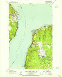
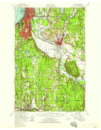
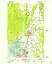
 1944 Everett1944 Print · USGSCovers Everett, including Bothell, Lake Stevens, and other nearby areas
 - 1953 Map of Mukilteo, 1955 Print
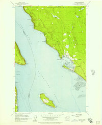
 1953 Mukilteo1955 Print · USGSCovers Everett, including Mukilteo, Clinton, and other nearby areas5 unique versions available
 - 1953 Map of Everett, 1955 Print
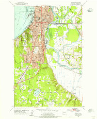 1953 Everett1955 Print · USGSCovers Everett, including Lake Stevens, Mill Creek, and other nearby areas4 unique versions available
 - 1953 Map of Everett, 1958 Print
 1953 Everett1958 Print · USGSCovers Everett, including Bothell, Lake Stevens, and other nearby areas2 unique versions available
 - 1953 Map of Edmonds, 1958 Print
 1953 Edmonds1958 Print · USGSCovers Everett, including Shoreline, Edmonds, and other nearby areas
 - 1956 Map of Tulalip, 1957 Print
 1956 Tulalip1957 Print · USGSCovers Everett, including Tulalip Bay, Cathan, and other nearby areas4 unique versions available
 - 1956 Map of Marysville, 1957 Print
 1956 Marysville1957 Print · USGSCovers Everett, including Marysville, Lake Stevens, and other nearby areas4 unique versions available
 - 1956 Map of Monroe, 1958 Print
 1956 Monroe1958 Print · USGSCovers Everett, including Monroe, Duvall, and other nearby areas2 unique versions available
 - 1957 Map of Victoria, 1960 Print
 1957 Victoria1960 Print · USGSCovers Everett, including Saanich, Bellingham, and other nearby areas4 unique versions available
 - 1957 Map of Wenatchee, 1973 Print
 1957 Wenatchee1973 Print · USGSCovers Everett, including Kent, Sammamish, and other nearby areas2 unique versions available
 - 1958 Map of Seattle, 1966 Print
 1958 Seattle1966 Print · USGSCovers Everett, including Seattle, Tacoma, and other nearby areas3 unique versions available
 - 1962 Map of Seattle
 1962 Seattle1962 Print · USGSCovers Everett, including Seattle, Tacoma, and other nearby areas
 - 1975 Map of Skykomish River, 1977 Print
 1975 Skykomish River1977 Print · USGSCovers Everett, including Sammamish, Issaquah, and other nearby areas2 unique versions available
 - 1975 Map of Seattle, 1977 Print
 1975 Seattle1977 Print · USGSCovers Everett, including Seattle, Bellevue, and other nearby areas
 - 1975 Map of Port Townsend, 1977 Print
 1975 Port Townsend1977 Print · USGSCovers Everett, including Marysville, Lake Stevens, and other nearby areas
 - 1989 Map of Lake Chaplain
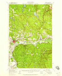
 1989 Lake Chaplain1989 Print · USGSCovers Everett, including Woods Creek, Sultan, and other nearby areas
Showing maps 1-25 of 29
Top cities near Everett
- Seattle historical maps
- Kirkland historical maps
- Marysville historical maps
- Bothell historical maps
- Lynnwood historical maps
- Lake Stevens historical maps
See more
Top neighborhoods of Everett
- Pinehurst historical maps
- South Forest Park historical maps
- Darlington historical maps
- Grandview Homes historical maps
- Harborview - Seahurst - Glenhaven historical maps
- Lowell historical maps
See more
Frequently asked questions
- What are the different types of historical maps available for Everett?
- What is the oldest map of Everett?
- Where can I purchase historical maps of Everett for my home or office?
- Where can I download high-res historical maps of Everett?
- Are there historical topographic maps available for Everett?
- Is there historical aerial imagery available for Everett?
- Where are historical maps of Everett sourced from?