1990s Maps of Everett, Washington
Explore 3 historic maps of Everett from the 1990s. These maps offer a rare glimpse into what life looked like during the 1990s — showing old roads, neighborhoods, homes, and landmarks that have changed or disappeared over time.
Whether you're researching your family's past, planning a metal detecting trip, or studying how Everett's landscape evolved across the 1990s, these high-resolution maps are a powerful tool for exploring the history of this region.
- Focus on a specific era: All maps on this page are from the 1990s, giving you a focused view of this time period.
- See what’s changed: Compare century-old streets, trails, and buildings to today's modern landscape using overlays and satellite layers.
- Research with precision: Use these maps for genealogy, historical research, land use analysis, or educational projects.
- View, download, or print: Maps are fully viewable online in high resolution, and can be downloaded or printed for your own records.
Start exploring Everett's history through authentic maps from the 1990s. This is your window into the past.
Everett, WA maps
(3)- 1992 Map of Seattle, 1993 Print
 1992 Seattle1993 Print · USGSThe Seattle metropolitan area and Puget Sound are shown here in the early nineties during a period of rapid suburban and technological growth. Researchers can trace the development of Mercer Island, locate the Bangor Naval Submarine Base, and study the industrial layout of Boeing Field.2 unique versions available
 - 1993 Map of Port Townsend
 1993 Port Townsend1993 Print · USGSThe Puget Sound and Whidbey Island are captured in the early nineties, showing a landscape defined by naval aviation and maritime trade. Genealogists and local historians can trace the development of Oak Harbor and Coupeville or locate family sites near the Arlington Municipal Cemetery and Ault Field.
 - 1997 Map of Lake Roesiger, 2003 Print
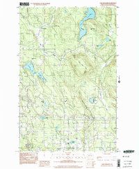 1997 Lake Roesiger2003 Print · USGSSnohomish County in the late nineties is a landscape of lakeside parks and timbered hills. Researchers can trace the development of Lake Roesiger and find old settlements like Forest Glade and Wagner alongside Three Lakes Hill.
End of results
Showing maps 1-3 of 3
Top cities near Everett
- Seattle historical maps
- Kirkland historical maps
- Marysville historical maps
- Bothell historical maps
- Lynnwood historical maps
- Lake Stevens historical maps
See more
Top neighborhoods of Everett
- Pinehurst historical maps
- Pinehurst - Beverly Park historical maps
- Bayside historical maps
- Riverside historical maps
- South Forest Park historical maps
- Cascade View historical maps
See more
Frequently asked questions
- What are the different types of historical maps available for Everett?
- What is the oldest map of Everett?
- Where can I purchase historical maps of Everett for my home or office?
- Where can I download high-res historical maps of Everett?
- Are there historical topographic maps available for Everett?
- Is there historical aerial imagery available for Everett?
- Where are historical maps of Everett sourced from?