
1992 Map of Seattle
USGS Topo · Published 1993About this map
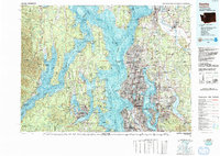
Puget Sound and the intricate waterways of the Kitsap Peninsula define this topographic-bathymetric study, which highlights the maritime and military infrastructure of the early 1990s. The map illustrates the sprawling development from Seattle and Everett to the expanding suburbs of Bellevue and Redmond. Vital defense installations such as the Bangor Naval Submarine Base and the Keyport Naval Undersea Warfare Center are shown alongside legacy sites like Fort Lawton. The region's transport network is well-established, featuring the Burlington Northern Railroad and Union Pacific Railroad corridors, plus significant aviation hubs including Seattle-Tacoma International Airport and Paine Field. On the water, bathymetric contours reveal the depths of Hood Canal and Possession Sound, while terrestrial detail covers the forested slopes of the Olympic Mountains and the Cascade Range. This document captures the Pacific Northwest at a point of high-tech growth, including the University of Washington campus and the industrial grounds of Boeing Field.
Find a feature on this map
305 named features on this map. Tap any name to fly to it.
Don’t see what you’re looking for? This feature index may not catch every label — zoom into the map to look around manually.
Map Details
Editions of this 1992 Seattle Map
2 editions found
Other maps of this area

1894 · Seattle
USGS Topo · 1:62,500

1895 · Snohomish
USGS Topo · 1:125,000

1897 · Tacoma
USGS Topo · 1:125,000

1897 · Seattle
USGS Topo · 1:125,000

1899 · Stillaguamish
USGS Topo · 1:125,000

1900 · Tacoma
USGS Topo · 1:125,000

1901 · Stilaguamish
USGS Topo · 1:125,000

1908 · Seattle
USGS Topo · 1:62,500

1909 · Seattle Special
USGS Topo · 1:62,500

1911 · Mount Vernon
USGS Topo · 1:125,000