Old Maps of King County, Washington
Explore 482 old maps of King County, spanning from 1894 to today. These high-resolution historic maps reveal how streets, neighborhoods, landmarks, and natural features evolved over time — perfect for genealogy, metal detecting, research, and local history exploration.
What you can do with these maps:
- See how King County changed over time: Compare historical maps to modern-day views to trace roads, homesites, rail lines & more.
- View detailed metadata: Each map includes creators, publishers, year, scale, and archive source.
- Overlay maps with satellite & LiDAR: Visualize the past alongside modern tools to explore terrain & human change.
- Trusted historical sources: Maps sourced from the USGS, Library of Congress, and other archives.
- Access maps your way: View online, download high-res files, or order prints for personal or research use.
Start exploring old maps of King County to uncover forgotten places, hidden landmarks, and the deep history beneath your feet.
King County, WA maps
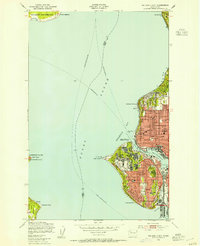
(482)- 1894 Map of Seattle, 1903 Print
 1894 Seattle1903 Print · USGSSeattle and its surrounding bay-side towns come alive in the 1890s, showing the region before modern industrialization reshaped the shoreline. Researchers can trace the original courses of the Dwamish River and locate early settlements like Ballard, West Seattle, and Ravenna.2 unique versions available
 - 1895 Map of Snohomish, 1954 Print
 1895 Snohomish1954 Print · USGSThe Puget Sound region in the late nineteenth century is documented here as Seattle and Everett rapidly expand via a growing rail network. Genealogists and historians can trace early waterfront settlements and inland junctions such as Mukilteo, Woodinville, and the grounds of Ft. Lawton.
 - 1897 Map of Tacoma
 1897 Tacoma1897 Print · USGSPuget Sound and the Tacoma waterfront come alive in the late 1890s, when coal railroads and river valleys drove regional growth. Genealogists can trace family roots in early island settlements like Chautauqua or inland rail towns such as Black Diamond and Wilkeson.2 unique versions available
 - 1897 Map of Seattle
 1897 Seattle1897 Print · USGSThe Puget Sound region is seen here in the late nineteenth century as the rail-and-water economy flourished. Genealogists and historians can trace early landings and rail stops like Curtis Landing, Moorland, and Kirkland Junction.10 unique versions available
 - 1900 Map of Tacoma
 1900 Tacoma1900 Print · USGSThe Puget Sound region was a hive of rail and maritime activity at the end of the Victorian era. Researchers can trace early settlements like Chautauqua, identify tribal lands at the Muckleshoot Indian Reservation, and locate mining towns such as Black Diamond.9 unique versions available
 - 1901 Map of Snoqualmie Pass, 1956 Print
 1901 Snoqualmie Pass1956 Print · USGSSnoqualmie Pass and the central Cascades are seen here during the early years of transcontinental rail expansion. Trace the original Northern Pacific route through the Stampede Tunnel and past early mountain stops like Easton, Hyak, and Ronald.2 unique versions available
 - 1902 Map of Skykomish
 1902 Skykomish1902 Print · USGSThe central Cascades were defined by the rail corridor at the turn of the century as the high passes were first conquered. Genealogists and historians can trace early mountain settlements like Monte Cristo, Mineral City, and Skykomish along the Great Northern Railway.
 - 1903 Map of Snoqualmie
 1903 Snoqualmie1903 Print · USGSThe Cascade Range at the turn of the century was a landscape of high-altitude rail engineering and timber potential. Trace the Northern Pacific RR through the Stampede Tunnel to early mountain settlements like Easton and Lester.6 unique versions available
 - 1905 Map of Skykomish
 1905 Skykomish1905 Print · USGSThe central Cascades at the start of the century reveal a landscape of high-altitude mining and the engineering of the Great Northern railroad. Trace early mountain settlements like Monte Cristo, the rail siding at Tonga, and the original Cascade Tunnel.7 unique versions available
 - 1908 Map of Seattle, 1955 Print
 1908 Seattle1955 Print · USGSSeattle's maritime and urban landscape is captured during a period of rapid growth and international attention. Genealogists and historians can trace neighborhood development near Ballard, the site of the Alaska-Yukon-Pacific Exposition, and landmarks like Fort Lawton.2 unique versions available
 - 1909 Map of Seattle Special
 1909 Seattle Special1909 Print · USGSThe Seattle waterfront and its surrounding hills appear here during the year of the Alaska-Yukon-Pacific Exposition. Genealogists and historians can trace early city neighborhoods and rail lines like the Seattle-Everett Interurban or locate Lakeview Cemetery and Fort Lawton.4 unique versions available
 - 1913 Map of Cedar Lake
 1913 Cedar Lake1913 Print · USGSThe foothills and peaks of the Cascades appear here just before World War I as industry pushed into the wilderness. Trace early timber and rail history through Kerriston, Selleck, and the Cedar Falls Power Plant.5 unique versions available
 - 1921 Map of Sultan
 1921 Sultan1921 Print · USGSThe Snoqualmie and Skykomish river valleys are defined by timber and rail in the 1920s. Researchers can trace early industry through the Apex Mines, Coke Ovens, and rural schools like Mountain View School.4 unique versions available
 - 1923 Map of Sultan
 1923 Sultan1923 Print · USGSThe Skykomish and Snoqualmie river valleys thrive in the early twenties as centers of timber and rail. Genealogists can trace family roots through rural sites like Forest Glade School or follow the Lumber RR lines to the Apex Mines.4 unique versions available
 - 1942 Map of Edmonds, 1944 Print
 1942 Edmonds1944 Print · USGSCoastal Snohomish County and Whidbey Island are captured in the early 1940s during a period of maritime and rail expansion. Researchers can trace historic ferry lines, the Great Northern railroad, and local landmarks like Alderwood Manor and Firlands Sanitarium.
 - 1942 Map of Gig Harbor, 1954 Print
 1942 Gig Harbor1954 Print · USGSThe Kitsap Peninsula and surrounding islands are mapped here during the early 1940s, highlighting a maritime world of inlets and ferries. Trace old family sites and rural landmarks like Elgin Sch, Lisabeula, and the many landings along Henderson Bay.
 - 1942 Map of Lake Tapps, 1962 Print
 1942 Lake Tapps1962 Print · USGSThe foothills of the Cascades meet the Puyallup Valley in the 1940s, showing a landscape defined by logging and coal extraction. Genealogists can locate family names on markers like Spar Pole Hill or trace rural social hubs like the Sunrise Grange Hall.3 unique versions available
 - 1943 Map of Gig Harbor
 1943 Gig Harbor1943 Print · USGSThe Puget Sound shoreline and its peninsulas are captured here in the 1940s as a maritime network of small landings and inland schools. Genealogists can trace family footprints at Sunny Slope Sch, Lisabeula, and the many homesteads near Artondale.
 - 1944 Map of Lake Tapps
 1944 Lake Tapps1944 Print · USGSPierce County during the early 1940s reveals a landscape of industrial river towns and hill-country resource extraction. Genealogists can trace family roots through the Kelly Lake Sch, Coal Mines near Wilkeson, and the Sunrise Grange Hall.3 unique versions available
 - 1944 Map of Everett
 1944 Everett1944 Print · USGSMid-century Snohomish County shows a landscape of industrial riverfronts and rural schoolhouses during the Second World War. Genealogists can trace family names at Cypress Lawn Cem, locate the CCC Camp, or find old school sites like Forbes Sch.
 - 1949 Map of Shilshole Bay, 1954 Print
 1949 Shilshole Bay1954 Print · USGSSeattle's northwestern waterfront is captured in the mid-century as neighborhoods like Ballard and Loyal Heights expand near the industrial shore. Trace the rail lines of the Great Northern and find historic sites like Fort Lawton and West Point Light.4 unique versions available
 - 1949 Map of Tacoma North, 1956 Print
 1949 Tacoma North1956 Print · USGSTacoma and its deep-water terminals appear at their industrial peak just after the war, showing the busy waterways of Commencement Bay. Researchers can trace the legacy of the Port of Tacoma, the grounds of the College of Puget Sound, and the early layout of Dash Point.
 - 1949 Map of Maple Valley, 1956 Print
 1949 Maple Valley1956 Print · USGSMaple Valley and its surrounding coal-rich mountains are documented here just after the war, showing the area's transition from mining to rural community life. Researchers can trace the Pacific Coast RR line past the Indian Coal Mine (Abandoned) and locate local landmarks like the Highline Cem and Maple Valley Sch.3 unique versions available
 - 1949 Map of Black Diamond, 1956 Print
 1949 Black Diamond1956 Print · USGSThe coal and timber country of King County is captured here just after the war, showing the industrial heart of Black Diamond and its rail connections. Genealogists can locate family sites near Morganville, the local Cem, or the Muckleshoot Indian Reservation.6 unique versions available
 - 1949 Map of Poverty Bay, 1956 Print
 1949 Poverty Bay1956 Print · USGSThe Puget Sound shoreline and the emerging Federal Way corridor are captured here during the late 1940s. Genealogists and local historians can trace early neighborhood footprints from Woodmont Beach to Madrona Heights and locate landmarks like Evergreen Airfield and Steel Lake Ch.
Showing maps 1-25 of 482
Top cities of King County
- Seattle historical maps
- Bellevue historical maps
- Kent historical maps
- Renton historical maps
- Federal Way historical maps
- Kirkland historical maps
See more
Frequently asked questions
- What are the different types of historical maps available for King County?
- What is the oldest map of King County?
- Where can I purchase historical maps of King County for my home or office?
- Where can I download high-res historical maps of King County?
- Are there historical topographic maps available for King County?
- Is there historical aerial imagery available for King County?
- Where are historical maps of King County sourced from?