1950s Maps of King County, Washington
Explore 32 historic maps of King County from the 1950s. These maps offer a rare glimpse into what life looked like during the 1950s — showing old roads, neighborhoods, homes, and landmarks that have changed or disappeared over time.
Whether you're researching your family's past, planning a metal detecting trip, or studying how King County's landscape evolved across the 1950s, these high-resolution maps are a powerful tool for exploring the history of this region.
- Focus on a specific era: All maps on this page are from the 1950s, giving you a focused view of this time period.
- See what’s changed: Compare century-old streets, trails, and buildings to today's modern landscape using overlays and satellite layers.
- Research with precision: Use these maps for genealogy, historical research, land use analysis, or educational projects.
- View, download, or print: Maps are fully viewable online in high resolution, and can be downloaded or printed for your own records.
Start exploring King County's history through authentic maps from the 1950s. This is your window into the past.
King County, WA maps
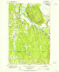
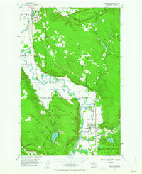
(32)- 1950 Map of Redmond, 1956 Print
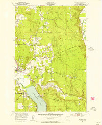 1950 Redmond1956 Print · USGSRedmond and the northern shores of Lake Sammamish are shown here in the early fifties before the rapid expansion of the Seattle suburbs. Researchers can trace the Northern Pacific line or locate small settlements like Adelaide, White, and Kenilworth.4 unique versions available
 - 1950 Map of Mercer Island, 1956 Print
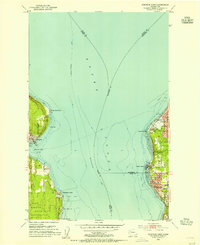
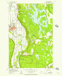
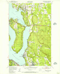 1950 Mercer Island1956 Print · USGSLake Washington’s eastern shores and the central expanse of MERCER ISLAND are captured here during the early 1950s. Researchers can locate vanished landmarks like the Bellevue Airfield, the Burbank Boys Sch, and the old mining community of Newcastle.4 unique versions available
 - 1950 Map of Issaquah, 1956 Print
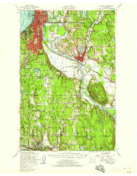
 1950 Issaquah1956 Print · USGSIssaquah and the eastern shores of Sammamish Lake are captured in the early 1950s before the arrival of modern interstate highways. Trace old transit lines like the Northern Pacific railroad and find local landmarks such as the Issaquah Airport and Monohon.4 unique versions available
 - 1950 Map of Kirkland, 1956 Print
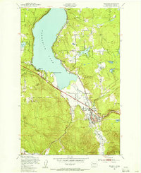
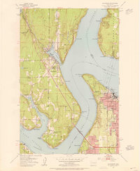
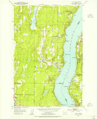
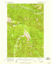
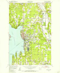 1950 Kirkland1956 Print · USGSThe King County shoreline on the eve of major suburban growth shows a landscape tied to the water and rail. Trace early neighborhoods and landmarks like the Seattle-Kirkland Ferry, the Northern Pacific line, and Bridle Trail State Park.4 unique versions available
 - 1953 Map of Snoqualmie, 1955 Print
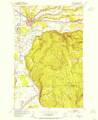
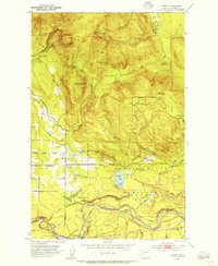
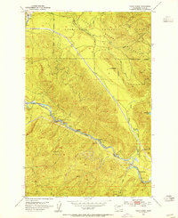
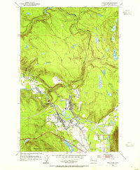 1953 Snoqualmie1955 Print · USGSThe Snoqualmie Valley in the early fifties shows a bustling hub of timber and rail operations centered around the river forks. Researchers can trace the massive Lumber Mill and Powerhouse near Snoqualmie Falls or find local landmarks like Mt Si High Sch.5 unique versions available
 - 1953 Map of North Bend, 1955 Print
 1953 North Bend1955 Print · USGSThe Snoqualmie Valley and the surrounding Cascades thrive with rail and timber activity in the early fifties. Local historians can trace the footprint of the Milwaukee Road, the Selleck community, and vanished locations like Hemlock (Site).4 unique versions available
 - 1953 Map of Sultan, 1955 Print
 1953 Sultan1955 Print · USGSThe river-and-rail corridor of the Skykomish Valley is captured here in the early fifties, centering on the town of Sultan. Researchers can trace the Great Northern line and discover upland features like Drunken Charlie Lake and the Old Railroad Grade.4 unique versions available
 - 1953 Map of Lake Joy, 1955 Print
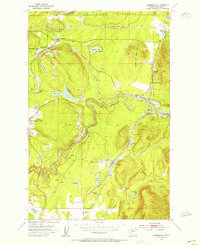
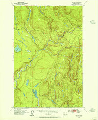 1953 Lake Joy1955 Print · USGSKing County timberlands and watersheds are captured here in the early fifties, showing the evolution of local logging infrastructure. Researchers can trace the Old Railroad Grade and Tolt Truck Trail past Lake Joy and the local Mill.4 unique versions available
 - 1953 Map of Gig Harbor, 1955 Print
 1953 Gig Harbor1955 Print · USGSThe maritime reaches of the Puget Sound come to life in the early fifties, showing the developing shores of the Kitsap Peninsula and Tacoma. Trace family roots at the Artondale Cem or explore historic sites like Ft Nisqually (Restoration) and the Tacoma Smelter.
 - 1953 Map of Edmonds West, 1955 Print
 1953 Edmonds West1955 Print · USGSPuget Sound communities and industrial shorelines are captured in detail during the early fifties. Genealogists and historians can trace the mid-century footprints of Edmonds and Kingston, or locate specific landmarks like the Naval Reservation and Point Wells facilities.5 unique versions available
 - 1953 Map of Monroe, 1955 Print
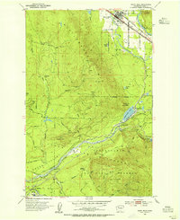
 1953 Monroe1955 Print · USGSMonroe and the fertile Skykomish River valley are seen here in the early fifties during a period of industrial and institutional growth. Researchers can trace the Milwaukee Road rail lines or locate landmarks like the State Reformatory and the Evergreen State Fairgrounds.4 unique versions available
 - 1953 Map of Bothell, 1955 Print
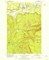
 1953 Bothell1955 Print · USGSThe Sammamish River valley in the early fifties shows a landscape of crossroads communities and timbered hills. Genealogists and local historians can trace family-named landmarks like Thrashers Corner or Turner Corner and locate early sites like Martha Lake School.5 unique versions available
 - 1953 Map of Maltby, 1955 Print
 1953 Maltby1955 Print · USGSSnohomish County in the early fifties shows a transition from river-valley agriculture to upland settlement near the three great river forks. Genealogists and historians can trace the State Reformatory, the Paradise Valley Cem, and old rail stops at Cathcart and Maltby.5 unique versions available
 - 1953 Map of Hobart, 1955 Print
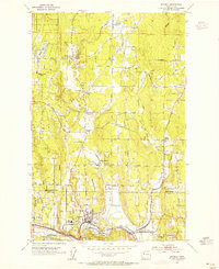
 1953 Hobart1955 Print · USGSThe foothills of the Cascades near Hobart are shown in the early 1950s as the region's timber and water resources were being actively managed. Researchers can find traces of mountain industry at the Tiger Mtn Mine, the old Taylor townsite, and the Shingle Mill.4 unique versions available
 - 1953 Map of Edmonds East, 1955 Print
 1953 Edmonds East1955 Print · USGSSuburban expansion north of Seattle is in full swing during the early fifties as new neighborhoods rise between the Sound and Lake Washington. Trace the development of Mountlake Terrace and Lynnwood alongside landmarks like Lake Ballinger and the Great Northern tracks.5 unique versions available
 - 1953 Map of Fall City, 1955 Print
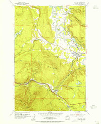 1953 Fall City1955 Print · USGSKing County's river valleys and timbered ridges are captured here during the 1950s, showing the intersection of rail and river life. Genealogists and historians can trace the foundations of Fall City and Preston, or locate the Reynolds Mine and Fall City Cemetery.5 unique versions available
 - 1953 Map of Olalla, 1955 Print
 1953 Olalla1955 Print · USGSThe Puget Sound shoreline comes alive in the early fifties, mapping the coastal communities of Kitsap County and Vashon Island. Trace family roots at Fraola Cemetery or explore the waterfront history of Olalla and Lisabeula.6 unique versions available
 - 1953 Map of Eagle Gorge, 1955 Print
 1953 Eagle Gorge1955 Print · USGSThe King County backcountry and its vital water infrastructure are detailed here in the mid-fifties. Researchers can trace the path of the Northern Pacific Railroad past Selleck and the Tacoma Water Supply Intake.3 unique versions available
 - 1953 Map of Cumberland, 1955 Print
 1953 Cumberland1955 Print · USGSKing County’s mining and rail corridors are captured here in the early 1950s, showing a landscape of coal towns and mountain transit. Researchers can trace the industrial footprints of Cumberland, Black Diamond, and Bayne alongside the Northern Pacific railroad.4 unique versions available
 - 1953 Map of Everett, 1958 Print
 1953 Everett1958 Print · USGSSnohomish County and the northern edge of King County are shown here during the post-war expansion of the mid-fifties. Researchers can trace the legacy of the timber and rail era through landmarks like the Great Northern Railway, Snohomish Airfield, and the Marshland Sch (Aban'd).2 unique versions available
 - 1953 Map of Edmonds, 1958 Print
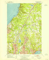
 1953 Edmonds1958 Print · USGSThe Snohomish County shoreline and southern Whidbey Island were undergoing a massive suburban shift in the early fifties. Researchers can trace the growth of Mountlake Terrace, locate old schoolhouses like Fairmont School, and find the Paine Field Air Force Base.
 - 1953 Map of Carnation, 1963 Print
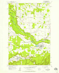
 1953 Carnation1963 Print · USGSThe Snoqualmie River valley in the early fifties shows a landscape of river-bottom farms and timbered hills. You can trace the rail lines of the Chicago Milwaukee St Paul and Pacific and locate sites like Carnation Farm and Stillwater.4 unique versions available
 - 1956 Map of Sumner, 1957 Print
 1956 Sumner1957 Print · USGSThe Puyallup and Stuck River valleys come alive in the mid-fifties as a bustling corridor of rail lines and early hydropower. Trace the industrial footprint of Dieringer or locate family roots near Alderton and the Kelly Lake Sch (Aban'd).4 unique versions available
 - 1956 Map of Greenwater, 1958 Print
 1956 Greenwater1958 Print · USGSThe Green River and White River valleys in the mid-1950s reveal a landscape of timber-rail settlements and mountain camps. Genealogists and historians can trace the Northern Pacific line through Nagrom or locate sites like Hot Springs and the Camp Sheppard Boy Scout Camp.4 unique versions available
 - 1956 Map of Buckley, 1958 Print
 1956 Buckley1958 Print · USGSPierce and King counties in the mid-fifties reveal a landscape of river-valley farms and emerging towns connected by the Northern Pacific. Genealogists can locate family sites near Krain Cem, South Prairie, and community hubs like Sunrise Grange.4 unique versions available
Showing maps 1-25 of 32
Top cities of King County
- Seattle historical maps
- Bellevue historical maps
- Kent historical maps
- Renton historical maps
- Federal Way historical maps
- Kirkland historical maps
See more
Frequently asked questions
- What are the different types of historical maps available for King County?
- What is the oldest map of King County?
- Where can I purchase historical maps of King County for my home or office?
- Where can I download high-res historical maps of King County?
- Are there historical topographic maps available for King County?
- Is there historical aerial imagery available for King County?
- Where are historical maps of King County sourced from?