1990s Maps of King County, Washington
Explore 24 historic maps of King County from the 1990s. These maps offer a rare glimpse into what life looked like during the 1990s — showing old roads, neighborhoods, homes, and landmarks that have changed or disappeared over time.
Whether you're researching your family's past, planning a metal detecting trip, or studying how King County's landscape evolved across the 1990s, these high-resolution maps are a powerful tool for exploring the history of this region.
- Focus on a specific era: All maps on this page are from the 1990s, giving you a focused view of this time period.
- See what’s changed: Compare century-old streets, trails, and buildings to today's modern landscape using overlays and satellite layers.
- Research with precision: Use these maps for genealogy, historical research, land use analysis, or educational projects.
- View, download, or print: Maps are fully viewable online in high resolution, and can be downloaded or printed for your own records.
Start exploring King County's history through authentic maps from the 1990s. This is your window into the past.
King County, WA maps
(24)- 1991 Map of Tacoma
 1991 Tacoma1991 Print · USGSThe South Sound and Tacoma waterfront appear here in the early nineties, showing a landscape defined by deep-water inlets and massive federal installations. Researchers can trace the development of Lakewood Center or locate the historic rail lines of the Burlington Northern Railroad and Union Pacific Railroad.
 - 1992 Map of Seattle, 1993 Print
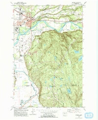
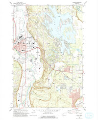
 1992 Seattle1993 Print · USGSThe Seattle metropolitan area and Puget Sound are shown here in the early nineties during a period of rapid suburban and technological growth. Researchers can trace the development of Mercer Island, locate the Bangor Naval Submarine Base, and study the industrial layout of Boeing Field.2 unique versions available
 - 1993 Map of Snoqualmie
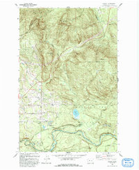
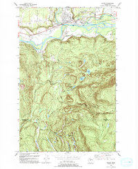
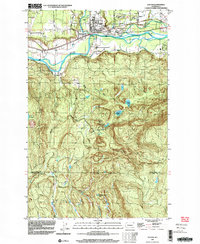
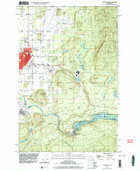
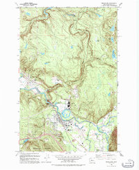 1993 Snoqualmie1993 Print · USGSSnoqualmie and North Bend are documented in the early nineties, showing a landscape defined by timber milling and river power. Researchers can trace the legacy of the Lumber Mill, the Snoqualmie Falls Powerhouse, and the remnants of the Old Railroad Grade.
 - 1993 Map of Fall City
 1993 Fall City1993 Print · USGSKing County's river valleys and foothills are captured here in the early nineties as suburban development began to blend with rural landscapes. Genealogists and historians can locate the Fall City Cemetery and trace the paths of the Old RR Grade and Tiger Mountain Trail.
 - 1993 Map of Cumberland
 1993 Cumberland1993 Print · USGSKing County's industrial and natural borders come into focus in the early 1990s as the Green River winds past established mining and rail towns. Genealogists and historians can trace the layouts of Cumberland, Black Diamond, and Ravensdale, or locate landmarks like the Black Diamond Bridge and Nolte State Park.
 - 1993 Map of Enumclaw
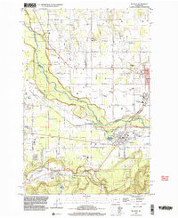
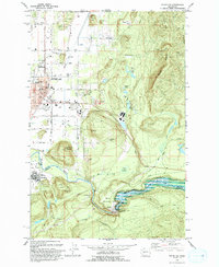 1993 Enumclaw1993 Print · USGSThe foothills of the Cascades near Enumclaw and Buckley are shown in the early nineties, centered on the White River corridor. Genealogists and historians can locate family landmarks like Pinnacle Peak, schools such as Byron Kibler Sch, and the massive Mud Mountain Dam infrastructure.
 - 1993 Map of Monroe
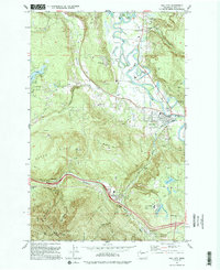
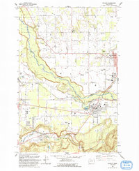
 1993 Monroe1993 Print · USGSThe Skykomish and Snoqualmie valleys meet here in the early nineties, showing a region defined by river-borne transit and state institutions. Trace family history at the IOOF Cem, or locate the State Reformatory and the Evergreen State Fairground.
 - 1993 Map of Eagle Gorge
 1993 Eagle Gorge1993 Print · USGSKing County's industrial and municipal water systems are on full display in the early nineties, focused on the Green River Watershed. Researchers can trace utility history through the Aqueduct, Purification Plant, and the Tacoma Water Supply Intake near Eagle Gorge.
 - 1993 Map of North Bend
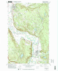
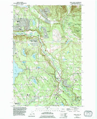
 1993 North Bend1993 Print · USGSNorth Bend and the Snoqualmie Valley are shown here in the early nineties, framed by the industrial and protective boundaries of the Cascades. Researchers can trace the footprints of old timber and mill towns like Kerriston, Barneston, and Selleck.2 unique versions available
 - 1993 Map of Buckley
 1993 Buckley1993 Print · USGSThe White River valley and the high prairies of Pierce and King counties are captured here in the early nineties. Researchers can trace the layout of Enumclaw and Buckley, locate the Krain Cemetery, and follow the Old RR Grade south toward Burnett.
 - 1993 Map of Lake Joy
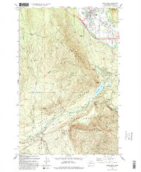
 1993 Lake Joy1993 Print · USGSKing County's water systems are meticulously charted here in the early nineties, showing a landscape defined by industrial forestry and utility. Trace the vital confluence of the North Fork Tolt River and the engineered Tolt Regulating Basin.
 - 1993 Map of Hobart
 1993 Hobart1993 Print · USGSThe Cedar River valley and its surrounding peaks are seen here in the early nineties, centered on the vital infrastructure of the Seattle municipal water system. You can trace the Burlington Northern Railroad through Landsburg and find local landmarks like Walsh Lake and the settlement of Hobart.
 - 1993 Map of Carnation
 1993 Carnation1993 Print · USGSThe Snoqualmie River valley in the early 1990s showcases a landscape of riverside towns and agricultural heritage. Researchers can trace the Old Grade Railroad and find local landmarks such as Carnation Farm, Stillwater Sch, and the community at Lake Marcel.
 - 1993 Map of Sultan
 1993 Sultan1993 Print · USGSSultan sits at the confluence of two major rivers in the early nineties, where timber history meets a growing valley community. Trace the remnants of the Old Railroad Grade or locate high-country landmarks like Drunken Charlie Lake and Lake Elsie.
 - 1993 Map of Sumner
 1993 Sumner1993 Print · USGSPierce County’s river valleys and the sprawling shoreline of Lake Tapps are shown here as they appeared in the early nineties. Researchers can trace the local landscape from Sumner city hall to landmarks like the Connells Prairie Battle Historical Marker and Victor Falls.
 - 1995 Map of Maple Valley
 1995 Maple Valley1995 Print · USGSThe Cedar River valley in the mid-1990s shows a landscape of growing residential enclaves and protected waters. Researchers can trace suburban development around Maple Valley or locate local landmarks like Dorre Don and the Lake Youngs Watershed.
 - 1997 Map of Edmonds West, 2003 Print
 1997 Edmonds West2003 Print · USGSPuget Sound’s busy maritime corridor is captured here in the late nineties, documenting the evolving shoreline from the Kitsap Peninsula to Edmonds. Maritime researchers can trace ferry lanes, locate a Sunken Wreck near Apple Cove Point, and see industrial sites like the oil tanks at Point Wells.
 - 1997 Map of Sultan, 2003 Print
 1997 Sultan2003 Print · USGSThe confluence of the Skykomish and Sultan rivers defines this late-century landscape, showing the town of Sultan as it transitioned from a timber hub to a growing residential community. Researchers can trace historic industrial footprints and local landmarks like the Cemetery, the Old Railroad Grade, and Drunken Charlie Lake.
 - 1997 Map of Enumclaw, 2003 Print
 1997 Enumclaw2003 Print · USGSEnumclaw and Buckley are shown during the late 1990s as the regional hub for the White River valley. Trace local history through the Rainier State School, the Old Grade Railroad, and engineered landmarks like the Mud Mountain Dam.
 - 1997 Map of Vashon, 2003 Print
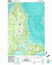 1997 Vashon2003 Print · USGSVashon and Maury Islands are shown at the close of the twentieth century, detailing the dense coastal settlements of the southern Sound. Genealogists and local historians can trace family properties near Burton, Ellisport, and the Vashon Municipal Airport.
 - 1997 Map of Poverty Bay, 2003 Print
 1997 Poverty Bay2003 Print · USGSCoastal development along the Puget Sound defines this late-nineties survey of the burgeoning Federal Way area. Genealogists and historians can trace family sites near Gethsemane Cemetery and older communities like Adelaide and Kitts Corner.
 - 1997 Map of Tacoma North, 2003 Print
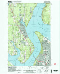
 1997 Tacoma North2003 Print · USGSThe industrial waterfront of Commencement Bay and the shores of Maury Island are captured in the late nineties, documenting a landscape of maritime commerce and island life. Trace the harbor's evolution through the Port of Tacoma, the Dash Point Lighthouse, and the historic Stadium High Sch.
 - 1997 Map of Buckley, 2003 Print
 1997 Buckley2003 Print · USGSThe foothills of King and Pierce counties are captured here in the late nineties as timber and rail heritage meets modern growth. Researchers can trace historic landmarks like Finn Hall, the Old RR Grade, and the grounds of the Rainier State School.
 - 1997 Map of Gig Harbor, 2003 Print
 1997 Gig Harbor2003 Print · USGSThe Gig Harbor peninsula and the Tacoma waterfront are shown here in the late nineties, connected by the iconic Tacoma Narrows Bridge. Genealogists and local historians can trace family-named sites and landmarks from Camp Sealth to Fort Nisqually.
End of results
Showing maps 1-24 of 24
Top cities of King County
- Seattle historical maps
- Bellevue historical maps
- Kent historical maps
- Renton historical maps
- Federal Way historical maps
- Kirkland historical maps
See more
Frequently asked questions
- What are the different types of historical maps available for King County?
- What is the oldest map of King County?
- Where can I purchase historical maps of King County for my home or office?
- Where can I download high-res historical maps of King County?
- Are there historical topographic maps available for King County?
- Is there historical aerial imagery available for King County?
- Where are historical maps of King County sourced from?