1970s Maps of King County, Washington
Explore 5 historic maps of King County from the 1970s. These maps offer a rare glimpse into what life looked like during the 1970s — showing old roads, neighborhoods, homes, and landmarks that have changed or disappeared over time.
Whether you're researching your family's past, planning a metal detecting trip, or studying how King County's landscape evolved across the 1970s, these high-resolution maps are a powerful tool for exploring the history of this region.
- Focus on a specific era: All maps on this page are from the 1970s, giving you a focused view of this time period.
- See what’s changed: Compare century-old streets, trails, and buildings to today's modern landscape using overlays and satellite layers.
- Research with precision: Use these maps for genealogy, historical research, land use analysis, or educational projects.
- View, download, or print: Maps are fully viewable online in high resolution, and can be downloaded or printed for your own records.
Start exploring King County's history through authentic maps from the 1970s. This is your window into the past.
King County, WA maps
(5)- 1975 Map of Snoqualmie Pass, 1977 Print
 1975 Snoqualmie Pass1977 Print · USGSThe central Cascades are shown here in the mid-seventies, just as the regional balance between industrial timber, rail transport, and recreation was shifting. Genealogists and hikers can trace old rail stops like Lester and Nagrom, or follow the Pacific Crest National Scenic Trail past Keechelus Lake.
 - 1975 Map of Skykomish River, 1977 Print
 1975 Skykomish River1977 Print · USGSThe Cascades meet the river valleys in the mid-seventies, showing the vital rail corridors and mountain towns along the Skykomish River. Researchers can trace the path of the Pacific Crest National Scenic Trail and locate historic sites like State Reformatory Farm No 2 and the Old Cascade Tunnel.2 unique versions available
 - 1975 Map of Tacoma, 1977 Print
 1975 Tacoma1977 Print · USGSThe Puget Sound region in the mid-seventies reveals a landscape of growing urban centers and massive federal installations. Genealogists and historians can trace the development of Tacoma and Olympia, or locate landmarks like the McNeil Island Penitentiary and Fort Lewis Military Reservation.
 - 1975 Map of Seattle, 1977 Print
 1975 Seattle1977 Print · USGSThe Puget Sound region in the mid-seventies shows a landscape of rapid suburban growth and vital maritime industry. Researchers can trace the development of Eastside hubs like Bellevue or examine the rail and naval infrastructure of Bremerton and Paine Field.
 - 1979 Map of Carnation, 1980 Print
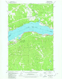 1979 Carnation1980 Print · USGSThe Columbia River Gorge in the late seventies reveals a bustling corridor of timber, rail, and recreation. Researchers can trace the Burlington Northern tracks, locate the Oxbow Salmon Hatchery, or find the historic St Martins Hot Springs.
End of results
Showing maps 1-5 of 5
Top cities of King County
- Seattle historical maps
- Bellevue historical maps
- Kent historical maps
- Renton historical maps
- Federal Way historical maps
- Kirkland historical maps
See more
Frequently asked questions
- What are the different types of historical maps available for King County?
- What is the oldest map of King County?
- Where can I purchase historical maps of King County for my home or office?
- Where can I download high-res historical maps of King County?
- Are there historical topographic maps available for King County?
- Is there historical aerial imagery available for King County?
- Where are historical maps of King County sourced from?