
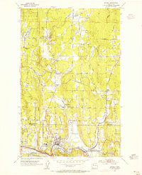
1950 Map of Redmond
USGS Topo · Published 1956About this map
Redmond serves as the focal point of this 1950s survey, situated at the confluence of Bear Creek and the Sammamish River. The landscape reflects a transitional era for King County, where the industrial footprint of the Northern Pacific railroad meets a geography still defined by small settlements and rural roads. North of Sammamish Lake, the terrain rises toward several distinct homesteads and localities, including Adelaide, White, and Hollywood. Notable infrastructure of the time, such as the Power Sta and the Northern Pacific rail line, highlights the growing utilities and transport network supporting these communities. To the east, the Snoqualmie River snakes through the valley, flanked by an Old Railroad Grade that hints at earlier logging or freight routes. This study also documents local cultural landmarks, from the Golf Course and Sportsman Park to a quiet Cem near the town center.
Find a feature on this map
27 named features on this map. Tap any name to fly to it.
Don’t see what you’re looking for? This feature index may not catch every label — zoom into the map to look around manually.
Map Details
Editions of this 1950 Redmond Map
4 editions found
Other maps of this area

1895 · Snohomish
USGS Topo · 1:125,000

1897 · Seattle
USGS Topo · 1:125,000

1921 · Sultan
USGS Topo · 1:125,000

1923 · Sultan
USGS Topo · 1:125,000

1944 · Everett
USGS Topo · 1:62,500
1950 · Mercer Island
USGS Topo · 1:24,000

1950 · Issaquah
USGS Topo · 1:24,000

1950 · Kirkland
USGS Topo · 1:24,000

1953 · Monroe
USGS Topo · 1:24,000
1953 · Bothell
USGS Topo · 1:24,000