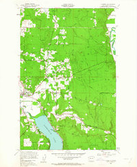
1950 Map of Redmond
USGS Topo · Published 1963About this map
Redmond serves as the focal point of this mid-century survey, situated at the confluence of several vital watercourses including the Sammamish River and Bear Creek. The map documents a landscape transitioning from rural agricultural tracts toward more defined suburban settlements, with small communities like Avondale and Hollywood scattered throughout the valley. The dominance of water-shaped geography is evident in the expanse of Sammamish Lake to the south and the winding Snoqualmie River in the northeast, while the presence of the Northern Pacific line and several stretches of Old Railroad Grade indicate the area's logistical history. Above the river valleys, Union Hill rises as a prominent topographical feature, crisscrossed by early thoroughfares such as Union Hill Road and Novelty Road. This period of development is further marked by recreational and industrial footprints, ranging from a local Golf Course and Sportsman Park to the utility infrastructure of the Power Sta.
Find a feature on this map
25 named features on this map. Tap any name to fly to it.
Don’t see what you’re looking for? This feature index may not catch every label — zoom into the map to look around manually.
Map Details
Editions of this 1950 Redmond Map
4 editions found
Other maps of this area

1895 · Snohomish
USGS Topo · 1:125,000

1897 · Seattle
USGS Topo · 1:125,000

1921 · Sultan
USGS Topo · 1:125,000

1923 · Sultan
USGS Topo · 1:125,000

1944 · Everett
USGS Topo · 1:62,500

1950 · Redmond
USGS Topo · 1:24,000
1950 · Mercer Island
USGS Topo · 1:24,000

1950 · Issaquah
USGS Topo · 1:24,000

1950 · Kirkland
USGS Topo · 1:24,000

1953 · Monroe
USGS Topo · 1:24,000