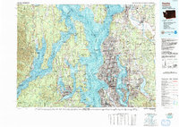
1992 Map of Seattle
USGS Topo · Published 1993About this map
Puget Sound and the intricate waterways of the Salish Sea dominate this topographic-bathymetric study, revealing a complex maritime and urban landscape at the end of the 20th century. The dense metropolitan core of Seattle is bounded by Lake Washington to the east, while the west side of the sound shows the significant military footprint of the Naval Submarine Base Bangor and the Puget Sound Naval Shipyard at Bremerton. This era is characterized by the high-profile infrastructure of the city, including the iconic Space Needle, the Kingdome, and the bustling Pike Place Market.
Find a feature on this map
305 named features on this map. Tap any name to fly to it.
Don’t see what you’re looking for? This feature index may not catch every label — zoom into the map to look around manually.
Map Details
Editions of this 1992 Seattle Map
2 editions found
Other maps of this area

1894 · Seattle
USGS Topo · 1:62,500

1895 · Snohomish
USGS Topo · 1:125,000

1897 · Tacoma
USGS Topo · 1:125,000

1897 · Seattle
USGS Topo · 1:125,000

1899 · Stillaguamish
USGS Topo · 1:125,000

1900 · Tacoma
USGS Topo · 1:125,000

1901 · Stilaguamish
USGS Topo · 1:125,000

1908 · Seattle
USGS Topo · 1:62,500

1909 · Seattle Special
USGS Topo · 1:62,500

1911 · Mount Vernon
USGS Topo · 1:125,000