1980s Maps of Everett, Washington
Explore 2 historic maps of Everett from the 1980s. These maps offer a rare glimpse into what life looked like during the 1980s — showing old roads, neighborhoods, homes, and landmarks that have changed or disappeared over time.
Whether you're researching your family's past, planning a metal detecting trip, or studying how Everett's landscape evolved across the 1980s, these high-resolution maps are a powerful tool for exploring the history of this region.
- Focus on a specific era: All maps on this page are from the 1980s, giving you a focused view of this time period.
- See what’s changed: Compare century-old streets, trails, and buildings to today's modern landscape using overlays and satellite layers.
- Research with precision: Use these maps for genealogy, historical research, land use analysis, or educational projects.
- View, download, or print: Maps are fully viewable online in high resolution, and can be downloaded or printed for your own records.
Start exploring Everett's history through authentic maps from the 1980s. This is your window into the past.
Everett, WA maps
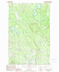
(2)- 1989 Map of Lake Chaplain
 1989 Lake Chaplain1989 Print · USGSSnohomish County water systems and forests are captured here in the late eighties, featuring the critical Lake Chaplain reservoir. Trace local industrial footprints through the Powerhouse, the Quarry, and an extensive Aqueduct network.
 - 1989 Map of Lake Roesiger
 1989 Lake Roesiger1989 Print · USGSSnohomish County’s lake country is captured here in the late eighties, showing a landscape of timbered hills and burgeoning rural settlements. Genealogists and hikers can trace old property lines near Forest Glade, explore the shores of Lake Roesiger, or locate the Sub Station near Wagner.
End of results
Showing maps 1-2 of 2
Top cities near Everett
- Seattle historical maps
- Kirkland historical maps
- Marysville historical maps
- Bothell historical maps
- Lynnwood historical maps
- Lake Stevens historical maps
See more
Top neighborhoods of Everett
- Pinehurst historical maps
- Pinehurst - Beverly Park historical maps
- Bayside historical maps
- Riverside historical maps
- South Forest Park historical maps
- Cascade View historical maps
See more
Frequently asked questions
- What are the different types of historical maps available for Everett?
- What is the oldest map of Everett?
- Where can I purchase historical maps of Everett for my home or office?
- Where can I download high-res historical maps of Everett?
- Are there historical topographic maps available for Everett?
- Is there historical aerial imagery available for Everett?
- Where are historical maps of Everett sourced from?