
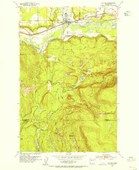
1989 Map of Lake Chaplain
USGS Topo · Published 1989About this map
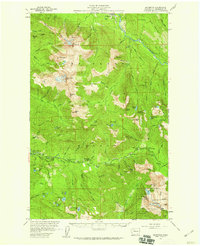
Snoqualmie National Forest dominates the northern and eastern portions of this 1989 provisional survey, showcasing a landscape defined by significant water management and varied terrain in Snohomish County. Centrally located, the expansive Lake Chaplain is a focal point of the area's utility, connected to an intricate Aqueduct system and an Aqueduct Tunnel that underscore the region's importance for local water resources. The Sultan River winds through the eastern side, passing the Powerhouse near Haywire Ridge.
Find a feature on this map
27 named features on this map. Tap any name to fly to it.
Don’t see what you’re looking for? This feature index may not catch every label — zoom into the map to look around manually.
Map Details
Editions of this 1989 Lake Chaplain Map
This is the sole edition of this map. No revisions or reprints were ever made.
Other maps of this area

1899 · Stillaguamish
USGS Topo · 1:125,000

1901 · Stilaguamish
USGS Topo · 1:125,000

1921 · Sultan
USGS Topo · 1:125,000

1923 · Sultan
USGS Topo · 1:125,000
1953 · Sultan
USGS Topo · 1:24,000
1953 · Monroe
USGS Topo · 1:24,000

1955 · Concrete
USGS Topo · 1:250,000
1956 · Monroe
USGS Topo · 1:62,500
1956 · Granite Falls
USGS Topo · 1:62,500
1957 · Silverton
USGS Topo · 1:62,500