
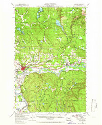
1956 Map of Monroe
USGS Topo · Published 1958About this map
The Skykomish River and Sultan River converge in this mid-century survey, defining a valley dominated by the timber industry and large-scale state institutions. The State Reformatory and the State Reformatory Farm No 2 occupy significant acreage south of the Monroe townsite, while the Evergreen State Fairgrounds sits near the rail junction. To the north, the landscape shifts into the foothills of the Snoqualmie Nat For, where the Intake Tower and Spillway 641 at Lake Chaplain indicate the region's importance for water management. Rural life is anchored by small settlements and family-named landmarks like the Wagner Sch and the Chief Seattle Boy Scout Reservation near Hughes Lake. The presence of numerous Gravel Pits and the Great Northern railroad tracks through Sultan illustrate the industrial transport network essential to Snohomish County during this era of growth.
Find a feature on this map
84 named features on this map. Tap any name to fly to it.
Don’t see what you’re looking for? This feature index may not catch every label — zoom into the map to look around manually.
Map Details
Editions of this 1956 Monroe Map
2 editions found
Other maps of this area

1895 · Snohomish
USGS Topo · 1:125,000

1897 · Seattle
USGS Topo · 1:125,000

1899 · Stillaguamish
USGS Topo · 1:125,000

1901 · Stilaguamish
USGS Topo · 1:125,000

1911 · Mount Vernon
USGS Topo · 1:125,000

1921 · Sultan
USGS Topo · 1:125,000

1923 · Sultan
USGS Topo · 1:125,000

1941 · Marysville
USGS Topo · 1:62,500

1943 · Marysville
USGS Topo · 1:62,500

1944 · Everett
USGS Topo · 1:62,500