
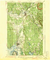
1943 Map of Marysville
USGS Topo · Published 1943About this map
The Stillaguamish River and its intricate network of sloughs and forks dominate this mid-century landscape of Snohomish County. The confluence at Arlington serves as a major hub for the Northern Pacific and Great Northern rail lines, reflecting the region's importance for timber and transit. To the south, the Tulalip Indian Reservation borders the growing town of Marysville, which is characterized by a grid of early streets and proximity to Ebey Slough. Local education is well-represented through numerous rural schoolhouses such as Shoultes Sch, Kellogg Marsh Sch, and Newburg Sch, which once served these timber and farming communities. The presence of a Landing Field near Edgecomb and the developed American Legion Memorial Park in Everett provide insight into the wartime era's civic and logistical infrastructure.
Find a feature on this map
72 named features on this map. Tap any name to fly to it.
Don’t see what you’re looking for? This feature index may not catch every label — zoom into the map to look around manually.
Map Details
Editions of this 1943 Marysville Map
2 editions found
Other maps of this area

1895 · Snohomish
USGS Topo · 1:125,000

1897 · Seattle
USGS Topo · 1:125,000

1899 · Stillaguamish
USGS Topo · 1:125,000

1901 · Stilaguamish
USGS Topo · 1:125,000

1911 · Mount Vernon
USGS Topo · 1:125,000

1921 · Sultan
USGS Topo · 1:125,000

1923 · Sultan
USGS Topo · 1:125,000

1940 · Mt Vernon
USGS Topo · 1:62,500

1941 · Marysville
USGS Topo · 1:62,500

1942 · Edmonds
USGS Topo · 1:62,500