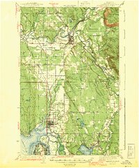
1943 Map of Marysville
USGS Topo · Published 1943About this map
The Tulalip Indian Reservation dominates the western shoreline of this 1941 survey, where the waters of Possession Sound meet a complex network of sloughs and river deltas. The landscape is defined by the convergence of the Stillagumish River and the Snohomish River, creating a low-lying patchwork of waterways including Steamboat Slough and Ebey Slough. Settlement patterns follow the competing lines of the Northern Pacific and Great Northern railroads, which anchor towns like Arlington, Marysville, and Getchell. Rural life is marked by numerous local schools serving the farming and timber communities, such as Kellogg Marsh Sch and Sunnyside Sch. Further east, the terrain rises toward Ebey Hill and the South Fork Stillaguamish River, while Lake Stevens serves as a prominent landmark in the southern reaches of the quadrangle.
Find a feature on this map
67 named features on this map. Tap any name to fly to it.
Don’t see what you’re looking for? This feature index may not catch every label — zoom into the map to look around manually.
Map Details
Editions of this 1943 Marysville Map
2 editions found

Other maps of this area

1895 · Snohomish
USGS Topo · 1:125,000

1897 · Seattle
USGS Topo · 1:125,000

1899 · Stillaguamish
USGS Topo · 1:125,000

1901 · Stilaguamish
USGS Topo · 1:125,000

1911 · Mount Vernon
USGS Topo · 1:125,000

1921 · Sultan
USGS Topo · 1:125,000

1923 · Sultan
USGS Topo · 1:125,000

1940 · Mt Vernon
USGS Topo · 1:62,500

1941 · Marysville
USGS Topo · 1:62,500

1942 · Edmonds
USGS Topo · 1:62,500