
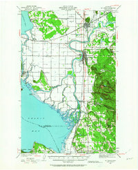
1940 Map of Mt Vernon
USGS Topo · Published 1957About this map
The Skagit River delta dominates this 1940 landscape, branching into the North Fork Skagit River and South Fork Skagit River around Fir Island. The region’s economic life is traced through its transport networks, where the Great Northern and Northern Pacific railroads intersect at Burlington and Mt Vernon. Along the eastern edge, a Logging Railroad snakes into the timbered foothills near Big Rock and Devils Mtn. A high concentration of rural education centers, including Ridgeway Sch, Pleasant Ridge Sch, and Riverside Sch, reflects a dispersed agrarian population. Waterfront life is evident at the fishing and milling centers of La Conner on the Swinomish Slough and the coastal settlement of Utsaladdy on Camano Island.
Find a feature on this map
62 named features on this map. Tap any name to fly to it.
Don’t see what you’re looking for? This feature index may not catch every label — zoom into the map to look around manually.
Map Details
Editions of this 1940 Mt Vernon Map
2 editions found
Other maps of this area

1911 · Mount Vernon
USGS Topo · 1:125,000

1918 · Samish Lake
USGS Topo · 1:62,500

1921 · Wickersham
USGS Topo · 1:62,500

1939 · Coupeville
USGS Topo · 1:62,500

1941 · Marysville
USGS Topo · 1:62,500

1943 · Marysville
USGS Topo · 1:62,500

1943 · Mt Vernon
USGS Topo · 1:62,500

1943 · Stanwood
USGS Topo · 1:62,500

1943 · Deception Pass
USGS Topo · 1:62,500

1943 · Anacortes
USGS Topo · 1:62,500