
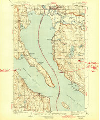
1943 Map of Stanwood
USGS Topo · Published 1943About this map
The Stillaguamish River snakes through the northern lowlands of this coastal Washington region, meeting the saltwater at Livingston Bay and Port Susan. This mid-century landscape is defined by its complex shoreline, where Camano Island and Whidbey Island shape the Saratoga Passage. In the bustling hub of Stanwood, the Lincoln High Sch stands near the intersection of the Great Northern railroad and the river delta.
Find a feature on this map
68 named features on this map. Tap any name to fly to it.
Don’t see what you’re looking for? This feature index may not catch every label — zoom into the map to look around manually.
Map Details
Editions of this 1943 Stanwood Map
2 editions found
Other maps of this area

1895 · Snohomish
USGS Topo · 1:125,000

1897 · Seattle
USGS Topo · 1:125,000

1911 · Mount Vernon
USGS Topo · 1:125,000

1937 · Port Gamble
USGS Topo · 1:62,500

1939 · Coupeville
USGS Topo · 1:62,500

1940 · Port Gamble
USGS Topo · 1:62,500

1940 · Mt Vernon
USGS Topo · 1:62,500

1941 · Marysville
USGS Topo · 1:62,500

1942 · Edmonds
USGS Topo · 1:62,500

1943 · Marysville
USGS Topo · 1:62,500