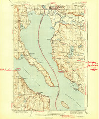
1943 Map of Stanwood
USGS Topo · Published 1943About this map
Camano Island and the coastal reaches of the Tulalip Indian Reservation define this maritime landscape at the confluence of the Stillaguamish River and the northern Puget Sound. Inland from Saratoga Passage, the map details a rural network of small settlements such as Warm Beach, Mabana, and Silvana, connected by the Great Northern railroad. The waterway between Port Susan and Livingston Bay is flanked by distinct communities, including the industrial hub of Stanwood and the quiet retreats of Mountain View Beach and Juniper Beach.
Find a feature on this map
67 named features on this map. Tap any name to fly to it.
Don’t see what you’re looking for? This feature index may not catch every label — zoom into the map to look around manually.
Map Details
Editions of this 1943 Stanwood Map
2 editions found

Other maps of this area

1895 · Snohomish
USGS Topo · 1:125,000

1897 · Seattle
USGS Topo · 1:125,000

1911 · Mount Vernon
USGS Topo · 1:125,000

1937 · Port Gamble
USGS Topo · 1:62,500

1939 · Coupeville
USGS Topo · 1:62,500

1940 · Port Gamble
USGS Topo · 1:62,500

1940 · Mt Vernon
USGS Topo · 1:62,500

1941 · Marysville
USGS Topo · 1:62,500

1942 · Edmonds
USGS Topo · 1:62,500

1943 · Marysville
USGS Topo · 1:62,500