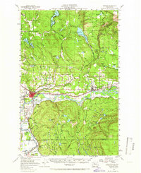
1956 Map of Monroe
USGS Topo · Published 1966About this map
The Skykomish River valley serves as the central corridor for this mid-century survey, where the town of Monroe functions as a vital agricultural and transportation hub. The landscape is defined by its transition from the fertile river bottoms and the Evergreen State Fairgrounds to the timbered reaches of the Snoqualmie National Forest. To the south, the Snoqualmie River carves a deep bend near Pearson Eddy, while the uplands are dotted with numerous glacial lakes such as Lake Roesiger, Flowing Lake, and Lake Hannan.
Find a feature on this map
91 named features on this map. Tap any name to fly to it.
Don’t see what you’re looking for? This feature index may not catch every label — zoom into the map to look around manually.
Map Details
Editions of this 1956 Monroe Map
2 editions found

Other maps of this area

1895 · Snohomish
USGS Topo · 1:125,000

1897 · Seattle
USGS Topo · 1:125,000

1899 · Stillaguamish
USGS Topo · 1:125,000

1901 · Stilaguamish
USGS Topo · 1:125,000

1911 · Mount Vernon
USGS Topo · 1:125,000

1921 · Sultan
USGS Topo · 1:125,000

1923 · Sultan
USGS Topo · 1:125,000

1941 · Marysville
USGS Topo · 1:62,500

1943 · Marysville
USGS Topo · 1:62,500

1944 · Everett
USGS Topo · 1:62,500