1950s Maps of Mill Creek, Washington
Explore 4 historic maps of Mill Creek from the 1950s. These maps offer a rare glimpse into what life looked like during the 1950s — showing old roads, neighborhoods, homes, and landmarks that have changed or disappeared over time.
Whether you're researching your family's past, planning a metal detecting trip, or studying how Mill Creek's landscape evolved across the 1950s, these high-resolution maps are a powerful tool for exploring the history of this region.
- Focus on a specific era: All maps on this page are from the 1950s, giving you a focused view of this time period.
- See what’s changed: Compare century-old streets, trails, and buildings to today's modern landscape using overlays and satellite layers.
- Research with precision: Use these maps for genealogy, historical research, land use analysis, or educational projects.
- View, download, or print: Maps are fully viewable online in high resolution, and can be downloaded or printed for your own records.
Start exploring Mill Creek's history through authentic maps from the 1950s. This is your window into the past.
Mill Creek, WA maps
(4)- 1953 Map of Bothell, 1955 Print
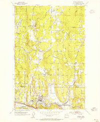 1953 Bothell1955 Print · USGSThe Sammamish River valley in the early fifties shows a landscape of crossroads communities and timbered hills. Genealogists and local historians can trace family-named landmarks like Thrashers Corner or Turner Corner and locate early sites like Martha Lake School.5 unique versions available
 - 1953 Map of Everett, 1955 Print
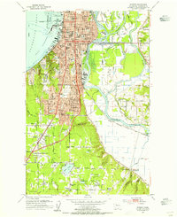 1953 Everett1955 Print · USGSMid-century Everett and its river sloughs are captured here during a period of significant post-war growth. Researchers can trace family sites at Evergreen Cemetery or locate early landmarks like the Childrens Home and the Sawmill.4 unique versions available
 - 1953 Map of Everett, 1958 Print
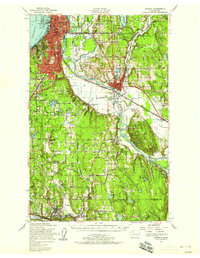 1953 Everett1958 Print · USGSSnohomish County and the northern edge of King County are shown here during the post-war expansion of the mid-fifties. Researchers can trace the legacy of the timber and rail era through landmarks like the Great Northern Railway, Snohomish Airfield, and the Marshland Sch (Aban'd).2 unique versions available
 - 1958 Map of Seattle, 1966 Print
 1958 Seattle1966 Print · USGSThe Puget Sound region in the mid-fifties showcases a balance of urban growth and Olympic wilderness. Trace the industrial waterfronts of Tacoma, old naval facilities like Keyport Naval Res, and mountain peaks like Mount Constance.3 unique versions available
End of results
Showing maps 1-4 of 4
Top cities near Mill Creek
- Seattle historical maps
- Bellevue historical maps
- Everett historical maps
- Kirkland historical maps
- Redmond historical maps
- Marysville historical maps
See more
Top neighborhoods of Mill Creek
- Osborn Corner historical maps
- Murphys Corner historical maps
- Aspen historical maps
- Evergreen historical maps
- Holly historical maps
- Juniper historical maps
See more
Frequently asked questions
- What are the different types of historical maps available for Mill Creek?
- What is the oldest map of Mill Creek?
- Where can I purchase historical maps of Mill Creek for my home or office?
- Where can I download high-res historical maps of Mill Creek?
- Are there historical topographic maps available for Mill Creek?
- Is there historical aerial imagery available for Mill Creek?
- Where are historical maps of Mill Creek sourced from?