1990s Maps of Chewelah, Washington
Explore 2 historic maps of Chewelah from the 1990s. These maps offer a rare glimpse into what life looked like during the 1990s — showing old roads, neighborhoods, homes, and landmarks that have changed or disappeared over time.
Whether you're researching your family's past, planning a metal detecting trip, or studying how Chewelah's landscape evolved across the 1990s, these high-resolution maps are a powerful tool for exploring the history of this region.
- Focus on a specific era: All maps on this page are from the 1990s, giving you a focused view of this time period.
- See what’s changed: Compare century-old streets, trails, and buildings to today's modern landscape using overlays and satellite layers.
- Research with precision: Use these maps for genealogy, historical research, land use analysis, or educational projects.
- View, download, or print: Maps are fully viewable online in high resolution, and can be downloaded or printed for your own records.
Start exploring Chewelah's history through authentic maps from the 1990s. This is your window into the past.
Chewelah, WA maps
(2)- 1992 Map of Chewelah, 1996 Print
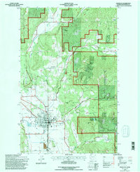 1992 Chewelah1996 Print · USGSIn the early 1990s, the Chewelah Valley was a hub of mining activity and rail transport beneath the Colville National Forest. Trace the deep history of local industry through landmarks like the United Copper No 1 Mine and the Burlington Northern rail line.
 - 1992 Map of Addy, 1997 Print
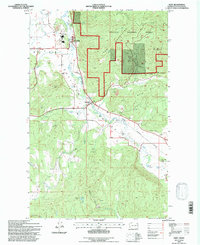 1992 Addy1997 Print · USGSThe Colville Valley comes into focus during the early nineties as a center for mining and rail transport. Genealogists and local historians can trace family-named landmarks and industrial sites like the Liberty Mine, the rail stop at Addy, and Traver Park.
End of results
Showing maps 1-2 of 2
Top cities near Chewelah
Frequently asked questions
- What are the different types of historical maps available for Chewelah?
- What is the oldest map of Chewelah?
- Where can I purchase historical maps of Chewelah for my home or office?
- Where can I download high-res historical maps of Chewelah?
- Are there historical topographic maps available for Chewelah?
- Is there historical aerial imagery available for Chewelah?
- Where are historical maps of Chewelah sourced from?