1980s Maps of La Crosse, Washington
Explore 3 historic maps of La Crosse from the 1980s. These maps offer a rare glimpse into what life looked like during the 1980s — showing old roads, neighborhoods, homes, and landmarks that have changed or disappeared over time.
Whether you're researching your family's past, planning a metal detecting trip, or studying how La Crosse's landscape evolved across the 1980s, these high-resolution maps are a powerful tool for exploring the history of this region.
- Focus on a specific era: All maps on this page are from the 1980s, giving you a focused view of this time period.
- See what’s changed: Compare century-old streets, trails, and buildings to today's modern landscape using overlays and satellite layers.
- Research with precision: Use these maps for genealogy, historical research, land use analysis, or educational projects.
- View, download, or print: Maps are fully viewable online in high resolution, and can be downloaded or printed for your own records.
Start exploring La Crosse's history through authentic maps from the 1980s. This is your window into the past.
La Crosse, WA maps
(3)- 1981 Map of La Crosse West
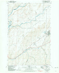 1981 La Crosse West1981 Print · USGSWhitman County agriculture and rail infrastructure are captured in the early 1980s as the town of La Crosse remains a hub for the local grain trade. Genealogists and researchers can trace the Union Pacific route, locate the Cem, and find rural landmarks like the Robert Camp Memorial Track.
 - 1981 Map of La Crosse East
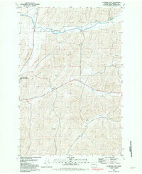 1981 La Crosse East1981 Print · USGSWhitman County, Washington, is captured here in the early 1980s, revealing a landscape shaped by rail transport and large-scale grain farming. Researchers can locate specific Grain Elevators and rural landmarks like Wasselman, Wies, and the Union Pacific line.
 - 1982 Map of Pullman
 1982 Pullman1982 Print · USGSThe Palouse region and Snake River valley are shown in the early eighties as the river navigation system matured. Trace the rail lines of the Union Pacific, locate rural centers like Johnson and Colton, and see the impact of the Lower Granite Dam.
End of results
Showing maps 1-3 of 3
Top cities near La Crosse
Top neighborhoods of La Crosse
Frequently asked questions
- What are the different types of historical maps available for La Crosse?
- What is the oldest map of La Crosse?
- Where can I purchase historical maps of La Crosse for my home or office?
- Where can I download high-res historical maps of La Crosse?
- Are there historical topographic maps available for La Crosse?
- Is there historical aerial imagery available for La Crosse?
- Where are historical maps of La Crosse sourced from?