1970s Maps of Grandview, Washington
Explore 2 historic maps of Grandview from the 1970s. These maps offer a rare glimpse into what life looked like during the 1970s — showing old roads, neighborhoods, homes, and landmarks that have changed or disappeared over time.
Whether you're researching your family's past, planning a metal detecting trip, or studying how Grandview's landscape evolved across the 1970s, these high-resolution maps are a powerful tool for exploring the history of this region.
- Focus on a specific era: All maps on this page are from the 1970s, giving you a focused view of this time period.
- See what’s changed: Compare century-old streets, trails, and buildings to today's modern landscape using overlays and satellite layers.
- Research with precision: Use these maps for genealogy, historical research, land use analysis, or educational projects.
- View, download, or print: Maps are fully viewable online in high resolution, and can be downloaded or printed for your own records.
Start exploring Grandview's history through authentic maps from the 1970s. This is your window into the past.
Grandview, WA maps
(2)- 1978 Map of Grandview, 1979 Print
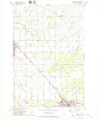 1978 Grandview1979 Print · USGSThe Yakima Valley thrives between Sunnyside and Grandview in the late seventies, showing a landscape defined by irrigation and rail. Trace the SUNNYSIDE CANAL network alongside landmarks like the Sunnyside-Grandview Speedway and Grange Hall.
 - 1979 Map of Sagebrush Ridge, 1980 Print
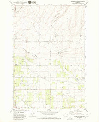 1979 Sagebrush Ridge1980 Print · USGSThe Yakima and Benton County line in the late seventies is defined by a high-desert landscape of irrigation canals and family-named roads. Genealogists and local historians can trace rural property markers like the Anderson Ranch and technical landmarks such as the Grandview Substation and Roza Canal.2 unique versions available
End of results
Showing maps 1-2 of 2
Top cities near Grandview
Top neighborhoods of Grandview
Frequently asked questions
- What are the different types of historical maps available for Grandview?
- What is the oldest map of Grandview?
- Where can I purchase historical maps of Grandview for my home or office?
- Where can I download high-res historical maps of Grandview?
- Are there historical topographic maps available for Grandview?
- Is there historical aerial imagery available for Grandview?
- Where are historical maps of Grandview sourced from?