Old Maps of Gromore, Washington for Genealogy
Trace your family roots with 7 historic maps of Gromore. These high-res maps reveal old neighborhoods, homesites, landmarks, and streets — helping you uncover where your ancestors lived and how the area evolved over time.
- Explore historic neighborhoods: Identify where your relatives may have lived in the 1800s or 1900s.
- Compare maps over time: Trace the changes in streets, buildings, and landmarks for multi-generational research.
- Perfect for genealogy & ancestry research: Used by family historians and researchers to map out lineage and migration.
These maps are an incredible resource for exploring your personal connection to Gromore's past.
Gromore, WA maps
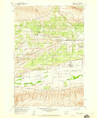
(7)- 1899 Map of Ellensburg, 1957 Print
 1899 Ellensburg1957 Print · USGSCentral Washington at the turn of the century shows a landscape of growing river towns and high ridges. Researchers can trace early railroad expansion along the Northern Pacific RR or locate rural outposts like Tampico, Ahtanum, and Nile.
 - 1901 Map of Ellensburg
 1901 Ellensburg1901 Print · USGSCentral Washington at the turn of the century shows a landscape shaped by river valleys and high ridges. Trace the early Northern Pacific Railway line through Ellensburg and the remote outposts of Nile and Tampico.6 unique versions available
 - 1950 Map of Yakima, 1951 Print
 1950 Yakima1951 Print · USGSThe Yakima Valley and the towering Cascades meet in this mid-century survey of South Central Washington. Genealogists and local historians can trace the irrigation-era growth of Yakima, the historic Fort Simcoe outpost, and the White Swan Mission on the Yakima Indian Reservation.
 - 1958 Map of Wiley City, 1960 Print
 1958 Wiley City1960 Print · USGSThe fertile Ahtanum Valley is captured here in the late fifties, showcasing a landscape defined by orchards and early irrigation. Researchers can locate Wiley City, the Tietonview Grange, and several tribal burial grounds like Saluskin Cemetery.3 unique versions available
 - 1958 Map of Yakima, 1964 Print
 1958 Yakima1964 Print · USGSThe Yakima Valley in the late fifties shows a landscape of mountain peaks and irrigated plains at the height of its rail-era development. Researchers can trace the lineage of early settlements through sites like Fort Simcoe, the Wenas Cemetery, and the Yakima Indian Agency School.3 unique versions available
 - 1961 Map of Yakima
 1961 Yakima1961 Print · USGSCentral Washington thrived in the mid-century as an agricultural powerhouse defined by the Yakima River. Trace local roots through Medicine Valley School, Fort Simcoe, and the rail lines of the Northern Pacific RR.
 - 2023 Map of Wiley City, 2023 Print
 2023 Wiley City2023 Print · USGSThe agricultural valleys west of Yakima are shown in this recent survey, capturing the network of canals and granges that define local life. Genealogists and researchers can locate several legacy burial grounds, including Saluskin Cem and Sloutier Cem, or trace water routes like Ahtanum Creek.
End of results
Showing maps 1-7 of 7
Top cities near Gromore
- Yakima historical maps
- Selah historical maps
- Union Gap historical maps
- Ahtanum historical maps
- Gleed historical maps
- Tieton historical maps
See more
Frequently asked questions
- What are the different types of historical maps available for Gromore?
- What is the oldest map of Gromore?
- Where can I purchase historical maps of Gromore for my home or office?
- Where can I download high-res historical maps of Gromore?
- Are there historical topographic maps available for Gromore?
- Is there historical aerial imagery available for Gromore?
- Where are historical maps of Gromore sourced from?