1960s Maps of Mabton, Washington
Explore 5 historic maps of Mabton from the 1960s. These maps offer a rare glimpse into what life looked like during the 1960s — showing old roads, neighborhoods, homes, and landmarks that have changed or disappeared over time.
Whether you're researching your family's past, planning a metal detecting trip, or studying how Mabton's landscape evolved across the 1960s, these high-resolution maps are a powerful tool for exploring the history of this region.
- Focus on a specific era: All maps on this page are from the 1960s, giving you a focused view of this time period.
- See what’s changed: Compare century-old streets, trails, and buildings to today's modern landscape using overlays and satellite layers.
- Research with precision: Use these maps for genealogy, historical research, land use analysis, or educational projects.
- View, download, or print: Maps are fully viewable online in high resolution, and can be downloaded or printed for your own records.
Start exploring Mabton's history through authentic maps from the 1960s. This is your window into the past.
Mabton, WA maps
(5)- 1961 Map of Yakima
 1961 Yakima1961 Print · USGSCentral Washington thrived in the mid-century as an agricultural powerhouse defined by the Yakima River. Trace local roots through Medicine Valley School, Fort Simcoe, and the rail lines of the Northern Pacific RR.
 - 1965 Map of Bluelight, 1966 Print
 1965 Bluelight1966 Print · USGSThe Yakima Valley and the Horse Heaven Hills meet in the 1960s, showing a landscape shaped by the Northern Pacific railroad and sprawling irrigation canals. Genealogists can locate the Glade Cem and Dorothy Sch, or trace old routes like the Chief Jeep Trail and Alderdale Road.
 - 1965 Map of Prosser, 1966 Print
 1965 Prosser1966 Print · USGSThe Yakima Valley in the mid-sixties shows a sophisticated network of canals and rail lines serving the growing communities of Prosser and Grandview. Genealogists and local historians can trace family-named sites like Young Ranch, find Mabton Cem, and locate rural schools such as School No 5.
 - 1965 Map of Mabton East, 1967 Print
 1965 Mabton East1967 Print · USGSThe Yakima Valley in the mid-sixties shows a landscape of irrigated orchards and riverfront industry between Mabton and Grandview. Genealogists and local historians can trace family-named landmarks and civic foundations like Artz Sch, Mabton Cemetery, and the Grange Hall.
 - 1965 Map of Mabton West, 1967 Print
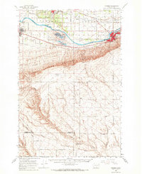
 1965 Mabton West1967 Print · USGSYakima County’s agricultural and rail corridor is captured here in the mid-sixties, centered on the riverside town of Mabton. Researchers can trace the path of the Northern Pacific railroad or locate local landmarks like the small Cem and several family-named roads.
End of results
Showing maps 1-5 of 5
Top cities near Mabton
- Sunnyside historical maps
- Grandview historical maps
- Prosser historical maps
- Granger historical maps
- Satus historical maps
- Outlook historical maps
Frequently asked questions
- What are the different types of historical maps available for Mabton?
- What is the oldest map of Mabton?
- Where can I purchase historical maps of Mabton for my home or office?
- Where can I download high-res historical maps of Mabton?
- Are there historical topographic maps available for Mabton?
- Is there historical aerial imagery available for Mabton?
- Where are historical maps of Mabton sourced from?