1960s Maps of Mossy, West Virginia
Explore 2 historic maps of Mossy from the 1960s. These maps offer a rare glimpse into what life looked like during the 1960s — showing old roads, neighborhoods, homes, and landmarks that have changed or disappeared over time.
Whether you're researching your family's past, planning a metal detecting trip, or studying how Mossy's landscape evolved across the 1960s, these high-resolution maps are a powerful tool for exploring the history of this region.
- Focus on a specific era: All maps on this page are from the 1960s, giving you a focused view of this time period.
- See what’s changed: Compare century-old streets, trails, and buildings to today's modern landscape using overlays and satellite layers.
- Research with precision: Use these maps for genealogy, historical research, land use analysis, or educational projects.
- View, download, or print: Maps are fully viewable online in high resolution, and can be downloaded or printed for your own records.
Start exploring Mossy's history through authentic maps from the 1960s. This is your window into the past.
Mossy, WV maps
(2)- 1961 Map of Bluefield
 1961 Bluefield1961 Print · USGSThe coalfields and mountain ridges of southern West Virginia and southwest Virginia are captured in the early sixties. Genealogists can trace family ties through rail-linked towns like Princeton and Richlands or along the shores of Bluestone Reservoir.
 - 1965 Map of Pax, 1966 Print
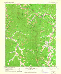 1965 Pax1966 Print · USGSWest Virginia coal country was in full swing when this mid-sixties survey documented the junction of Fayette and Raleigh counties. Genealogists can trace family landmarks like Workman Cem and Pax Sch alongside the tracks of the Norfolk and Western rail line.3 unique versions available
End of results
Showing maps 1-2 of 2
Top cities near Mossy
- Beckley historical maps
- Oak Hill historical maps
- Fayetteville historical maps
- Montgomery historical maps
- Ansted historical maps
- Mount Hope historical maps
See more
Frequently asked questions
- What are the different types of historical maps available for Mossy?
- What is the oldest map of Mossy?
- Where can I purchase historical maps of Mossy for my home or office?
- Where can I download high-res historical maps of Mossy?
- Are there historical topographic maps available for Mossy?
- Is there historical aerial imagery available for Mossy?
- Where are historical maps of Mossy sourced from?