1900s (20th Century) Maps of Alvon, West Virginia
Explore 10 historic maps of Alvon from the 1900s (20th Century). These maps offer a rare glimpse into what life looked like during the 1900s — showing old roads, neighborhoods, homes, and landmarks that have changed or disappeared over time.
Whether you're researching your family's past, planning a metal detecting trip, or studying how Alvon's landscape evolved across the 1900s, these high-resolution maps are a powerful tool for exploring the history of this region.
- Focus on a specific era: All maps on this page are from the 1900s, giving you a focused view of this time period.
- See what’s changed: Compare century-old streets, trails, and buildings to today's modern landscape using overlays and satellite layers.
- Research with precision: Use these maps for genealogy, historical research, land use analysis, or educational projects.
- View, download, or print: Maps are fully viewable online in high resolution, and can be downloaded or printed for your own records.
Start exploring Alvon's history through authentic maps from the 1900s. This is your window into the past.
Alvon, WV maps
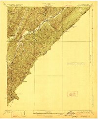
(10)- 1921 Map of Callaghan
 1921 Callaghan1921 Print · USGSThe West Virginia and Virginia borderlands come alive in this early 1920s survey of the mountain gaps and valley drafts. Researchers can trace rural life through numerous country schools like Bound School and landmarks such as Columbia Sulphur Springs and Wileys Crossing.
 - 1923 Map of Callaghan
 1923 Callaghan1923 Print · USGSThe West Virginia and Virginia borderlands come alive in the early 1920s, showing a landscape of remote schoolhouses and mineral springs. Genealogists can trace family footprints near Columbia Sulphur Springs or locate long-gone schools like Wades Draft School and Whites Draft School.3 unique versions available
 - 1946 Map of Callaghan
 1946 Callaghan1946 Print · USGSThe Virginia and West Virginia borderlands are captured here in the mid-1940s, showing the intersection of heavy rail and mountain life. Genealogists and historians can trace old community sites like Hokes Chapel, Dunlap Sch, and the industrial operations at Stack Mine.4 unique versions available
 - 1949 Map of Callaghan
 1949 Callaghan1949 Print · USGSThe Virginia and West Virginia borderlands come alive in this mid-century survey of the high Allegheny ridges and river valleys. Genealogists and researchers can trace the Chesapeake and Ohio rail line to vanished stops like Backbone Siding or locate family sites near Hokes Chapel and Whites Draft Sch.2 unique versions available
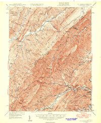
 - 1955 Map of Bluefield
 1955 Bluefield1955 Print · USGSThe Central Appalachian borderlands come alive in the mid-fifties, showing the coal and rail networks connecting Bluefield to Beckley. Researchers can trace the industrial landscape of the New River Ordnance Plant and the terrain of Burkes Garden.
 - 1957 Map of Bluefield, 1967 Print
 1957 Bluefield1967 Print · USGSThe heart of Central Appalachia in the mid-fifties is defined by the winding rail lines and river valleys of the coalfields. Researchers can trace the industrial footprints of towns like Welch and Princeton or locate landmarks such as the Bluestone Reservoir and Claytor Lake.2 unique versions available
 - 1961 Map of Bluefield
 1961 Bluefield1961 Print · USGSThe coalfields and mountain ridges of southern West Virginia and southwest Virginia are captured in the early sixties. Genealogists can trace family ties through rail-linked towns like Princeton and Richlands or along the shores of Bluestone Reservoir.
 - 1969 Map of Alvon, 1971 Print
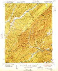
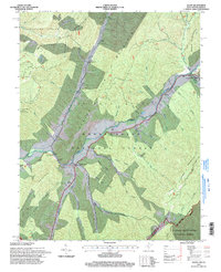
 1969 Alvon1971 Print · USGSGreenbrier County is captured here in the late sixties as its mountain communities and forest lands intersect along the Allegheny front. Researchers can trace the footprints of Alvon, Neola, and the Little Creek Ch amidst the vast timberlands of the Monongahela National Forest.3 unique versions available
 - 1984 Map of Lewisburg, 1985 Print
 1984 Lewisburg1985 Print · USGSThe Greenbrier Valley in the mid-eighties shows a landscape of river-town commerce, mountain agriculture, and major institutional landmarks. Researchers can trace the rail corridors of the Chesapeake and Ohio and locate sites like the Federal Reformatory for Women and the Sam Black Church.2 unique versions available
 - 1995 Map of Alvon, 1998 Print
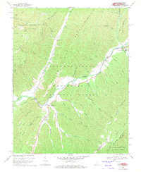
 1995 Alvon1998 Print · USGSGreenbrier County, West Virginia, is shown in the mid-1990s as a forested mountain landscape where the state border meets two national forests. Researchers can trace rural life and industry through labels for Neola, Anthony Creek Sch, and the Anthony Correctional Center.
End of results
Showing maps 1-10 of 10
Top cities near Alvon
- Covington historical maps
- Lewisburg historical maps
- White Sulphur Springs historical maps
- Hillsboro historical maps
- Callaghan historical maps
- Falling Spring historical maps
Frequently asked questions
- What are the different types of historical maps available for Alvon?
- What is the oldest map of Alvon?
- Where can I purchase historical maps of Alvon for my home or office?
- Where can I download high-res historical maps of Alvon?
- Are there historical topographic maps available for Alvon?
- Is there historical aerial imagery available for Alvon?
- Where are historical maps of Alvon sourced from?