1970s Maps of Clintonville, West Virginia
Explore 1 historic maps of Clintonville from the 1970s. These maps offer a rare glimpse into what life looked like during the 1970s — showing old roads, neighborhoods, homes, and landmarks that have changed or disappeared over time.
Whether you're researching your family's past, planning a metal detecting trip, or studying how Clintonville's landscape evolved across the 1970s, these high-resolution maps are a powerful tool for exploring the history of this region.
- Focus on a specific era: All maps on this page are from the 1970s, giving you a focused view of this time period.
- See what’s changed: Compare century-old streets, trails, and buildings to today's modern landscape using overlays and satellite layers.
- Research with precision: Use these maps for genealogy, historical research, land use analysis, or educational projects.
- View, download, or print: Maps are fully viewable online in high resolution, and can be downloaded or printed for your own records.
Start exploring Clintonville's history through authentic maps from the 1970s. This is your window into the past.
Clintonville, WV maps
(1)- 1972 Map of Cornstalk, 1974 Print
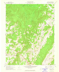 1972 Cornstalk1974 Print · USGSGreenbrier County's high ridges and quiet hollows are captured here in the early seventies, showing the transition from the summits of Buffalo Mountain to the farms of Clintonville. Local researchers can locate remote landmarks like Kuhn Glades and family-linked sites such as James Chapel or the Wallace Memorial Cem.2 unique versions available
End of results
Showing maps 1-1 of 1
Top cities near Clintonville
- Lewisburg historical maps
- Fairlea historical maps
- Ronceverte historical maps
- Rainelle historical maps
- Rupert historical maps
- Quinwood historical maps
Frequently asked questions
- What are the different types of historical maps available for Clintonville?
- What is the oldest map of Clintonville?
- Where can I purchase historical maps of Clintonville for my home or office?
- Where can I download high-res historical maps of Clintonville?
- Are there historical topographic maps available for Clintonville?
- Is there historical aerial imagery available for Clintonville?
- Where are historical maps of Clintonville sourced from?