1930s Maps of Grassy Meadows, West Virginia
Explore 2 historic maps of Grassy Meadows from the 1930s. These maps offer a rare glimpse into what life looked like during the 1930s — showing old roads, neighborhoods, homes, and landmarks that have changed or disappeared over time.
Whether you're researching your family's past, planning a metal detecting trip, or studying how Grassy Meadows's landscape evolved across the 1930s, these high-resolution maps are a powerful tool for exploring the history of this region.
- Focus on a specific era: All maps on this page are from the 1930s, giving you a focused view of this time period.
- See what’s changed: Compare century-old streets, trails, and buildings to today's modern landscape using overlays and satellite layers.
- Research with precision: Use these maps for genealogy, historical research, land use analysis, or educational projects.
- View, download, or print: Maps are fully viewable online in high resolution, and can be downloaded or printed for your own records.
Start exploring Grassy Meadows's history through authentic maps from the 1930s. This is your window into the past.
Grassy Meadows, WV maps
(2)- 1935 Map of Clintonville, 1962 Print
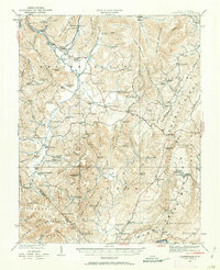 1935 Clintonville1962 Print · USGSGreenbrier County is captured here in the mid-1930s, showing a landscape defined by small farming hamlets and a remarkable density of rural schools. Researchers can locate family landmarks like Berrys Mill, the landmark Sam Black Church, and the mineral waters of Blue Sulphur Springs.
 - 1939 Map of Clintonville
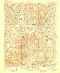 1939 Clintonville1939 Print · USGSGreenbrier County's high ridges and creek valleys are documented here in the late 1930s, showing a landscape thick with local institutions. Genealogists can locate dozens of historic schools and churches, from Sam Black Church and Berrys Mill to the remote Sawmill Hollow School.2 unique versions available
End of results
Showing maps 1-2 of 2
Top cities near Grassy Meadows
- Hinton historical maps
- Ronceverte historical maps
- Rainelle historical maps
- Rupert historical maps
- Meadow Bridge historical maps
Frequently asked questions
- What are the different types of historical maps available for Grassy Meadows?
- What is the oldest map of Grassy Meadows?
- Where can I purchase historical maps of Grassy Meadows for my home or office?
- Where can I download high-res historical maps of Grassy Meadows?
- Are there historical topographic maps available for Grassy Meadows?
- Is there historical aerial imagery available for Grassy Meadows?
- Where are historical maps of Grassy Meadows sourced from?