1900s (20th Century) Maps of Renicks Valley, West Virginia
Explore 12 historic maps of Renicks Valley from the 1900s (20th Century). These maps offer a rare glimpse into what life looked like during the 1900s — showing old roads, neighborhoods, homes, and landmarks that have changed or disappeared over time.
Whether you're researching your family's past, planning a metal detecting trip, or studying how Renicks Valley's landscape evolved across the 1900s, these high-resolution maps are a powerful tool for exploring the history of this region.
- Focus on a specific era: All maps on this page are from the 1900s, giving you a focused view of this time period.
- See what’s changed: Compare century-old streets, trails, and buildings to today's modern landscape using overlays and satellite layers.
- Research with precision: Use these maps for genealogy, historical research, land use analysis, or educational projects.
- View, download, or print: Maps are fully viewable online in high resolution, and can be downloaded or printed for your own records.
Start exploring Renicks Valley's history through authentic maps from the 1900s. This is your window into the past.
Renicks Valley, WV maps
(12)- 1923 Map of Lobelia
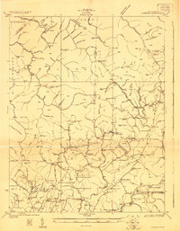 1923 Lobelia1923 Print · USGSGreenbrier and Pocahontas Counties are shown in the early 1920s as mountain farming and timber harvesting shaped the landscape. Researchers can trace dozens of rural institutions, from Ellis Chapel and Band of Hope Church to remote schools like West Droop School.2 unique versions available
 - 1925 Map of Lobelia
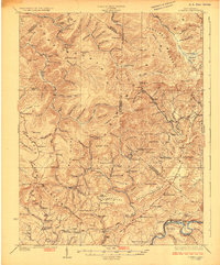 1925 Lobelia1925 Print · USGSThe mountains and wetlands of Greenbrier County are captured here in the mid-1920s, showing a landscape of high ridges and rural valley settlements. Trace old family sites and mountain outposts like Lobelia, Trout Valley, and the Cranberry Glades.2 unique versions available
 - 1935 Map of Lobelia, 1959 Print
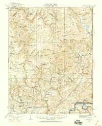 1935 Lobelia1959 Print · USGSThe Greenbrier County backcountry is shown in the mid-1930s, just as the regional forest service infrastructure was expanding. Genealogists and historians can trace numerous rural schoolhouses and churches, from Beulah Church to the Baldwin School and the remote Trout PO.2 unique versions available
 - 1939 Map of Lobelia
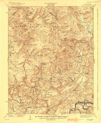 1939 Lobelia1939 Print · USGSGreenbrier and Pocahontas counties appear here in the years before the war, characterized by high mountain plateaus and a dense network of rural schoolhouses. Researchers can trace family roots through sites like Rockcamp Cem, Bethel Church, and the Trout Valley Trout Post Office.2 unique versions available
 - 1954 Map of Charleston
 1954 Charleston1954 Print · USGSWest Virginia’s industrial heart and mountain highlands are captured here during the mid-fifties, centered on the capital city. Researchers can trace historic river-and-rail corridors along the Kanawha River and locate remote peaks within the Monongahela National Forest.
 - 1957 Map of Charleston, 1966 Print
 1957 Charleston1966 Print · USGSMid-century West Virginia unfolds along the industrial Kanawha River valley and into the high Allegheny Mountains. Genealogists and historians can trace the vital rail lines of the Chesapeake and Ohio and locate riverside settlements from Saint Albans to Buckhannon.3 unique versions available
 - 1958 Map of Charleston
 1958 Charleston1958 Print · USGSMid-century West Virginia is defined here by the industrial corridor of the Kanawha River and the high ridges of the Allegheny Mountains. Researchers can trace the rail networks of the New York Central or locate remote highland communities like Pickens and Hillsboro.
 - 1961 Map of Charleston
 1961 Charleston1961 Print · USGSWest Virginia's capital region and the highlands to the east are shown in detail during the early sixties. Genealogists and historians can trace rail networks like the Baltimore and Ohio RR and find early state parks such as Watoga State Park.
 - 1973 Map of Droop, 1989 Print
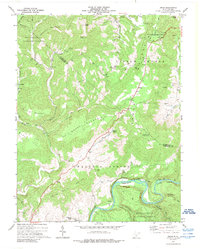 1973 Droop1989 Print · USGSHighland ridges and river valleys define this part of Greenbrier County in the early seventies, centered on the site of a historic battlefield. Local researchers can trace family names and landmarks like Renicks Valley, Mt Zion Ch, and the Covered Bridge along Locust Creek.
 - 1977 Map of Droop, 1978 Print
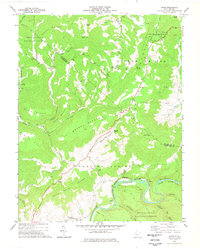 1977 Droop1978 Print · USGSGreenbrier and Pocahontas counties meet in this mid-1970s mountain survey, where high ridges overlook the river-and-rail corridor. You can trace family sites near Whiteoak Grove, locate the Covered Bridge at Droop, and explore the grounds of Droop Mountain Battlefield State Park.
 - 1979 Map of Marlinton, 1982 Print
 1979 Marlinton1982 Print · USGSThe West Virginia highlands are shown in detail during the late seventies, featuring the dense rail networks and mountain towns of the Allegheny range. Researchers can trace family roots through sites like Buckeye Cem, Mount Nebo Ch, and the lumber and coal hubs of Richwood and Rainelle.
 - 1995 Map of Droop, 1998 Print
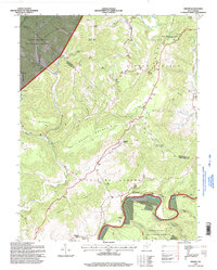 1995 Droop1998 Print · USGSThe Greenbrier highlands come into focus in the mid-nineties, showing the intersection of agricultural plateaus and national forest wilderness. Genealogists can trace family landmarks like Sunset Cem and Kellison Cem near Droop or the Covered Bridge on Locust Creek.
End of results
Showing maps 1-12 of 12
Top cities near Renicks Valley
- Lewisburg historical maps
- Richwood historical maps
- Marlinton historical maps
- Hillsboro historical maps
- Falling Spring historical maps
Frequently asked questions
- What are the different types of historical maps available for Renicks Valley?
- What is the oldest map of Renicks Valley?
- Where can I purchase historical maps of Renicks Valley for my home or office?
- Where can I download high-res historical maps of Renicks Valley?
- Are there historical topographic maps available for Renicks Valley?
- Is there historical aerial imagery available for Renicks Valley?
- Where are historical maps of Renicks Valley sourced from?