1950s Maps of Charleston, West Virginia
Explore 8 historic maps of Charleston from the 1950s. These maps offer a rare glimpse into what life looked like during the 1950s — showing old roads, neighborhoods, homes, and landmarks that have changed or disappeared over time.
Whether you're researching your family's past, planning a metal detecting trip, or studying how Charleston's landscape evolved across the 1950s, these high-resolution maps are a powerful tool for exploring the history of this region.
- Focus on a specific era: All maps on this page are from the 1950s, giving you a focused view of this time period.
- See what’s changed: Compare century-old streets, trails, and buildings to today's modern landscape using overlays and satellite layers.
- Research with precision: Use these maps for genealogy, historical research, land use analysis, or educational projects.
- View, download, or print: Maps are fully viewable online in high resolution, and can be downloaded or printed for your own records.
Start exploring Charleston's history through authentic maps from the 1950s. This is your window into the past.
Charleston, WV maps
(8)- 1954 Map of Charleston
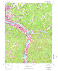
 1954 Charleston1954 Print · USGSWest Virginia’s industrial heart and mountain highlands are captured here during the mid-fifties, centered on the capital city. Researchers can trace historic river-and-rail corridors along the Kanawha River and locate remote peaks within the Monongahela National Forest.
 - 1957 Map of Charleston East, 1959 Print
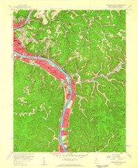 1957 Charleston East1959 Print · USGSThe West Virginia state capital and its industrial river corridor are captured in the late fifties as the turnpike and suburbs expanded. Researchers can trace mid-century landmarks like Morris Harvey College, the State Capitol, and the Kanawha Airport.3 unique versions available
 - 1957 Map of Charleston, 1966 Print
 1957 Charleston1966 Print · USGSMid-century West Virginia unfolds along the industrial Kanawha River valley and into the high Allegheny Mountains. Genealogists and historians can trace the vital rail lines of the Chesapeake and Ohio and locate riverside settlements from Saint Albans to Buckhannon.3 unique versions available
 - 1958 Map of Charleston
 1958 Charleston1958 Print · USGSMid-century West Virginia is defined here by the industrial corridor of the Kanawha River and the high ridges of the Allegheny Mountains. Researchers can trace the rail networks of the New York Central or locate remote highland communities like Pickens and Hillsboro.
 - 1958 Map of Charleston West, 1959 Print
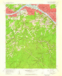 1958 Charleston West1959 Print · USGSThe Kanawha River valley was a bustling corridor of industry and education in the late fifties, from the Naval Ordnance Plant to the city centers. Genealogists and historians can trace neighborhood growth in South Hills or locate family markers in Sunset Memorial Cemetery and Graceland Cem.4 unique versions available
 - 1958 Map of Big Chimney, 1960 Print
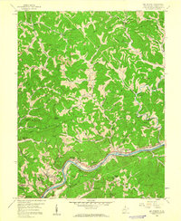 1958 Big Chimney1960 Print · USGSIn the late 1950s, the Elk River valley served as a busy corridor for industry and new infrastructure like the Kanawha Airport. Genealogists can trace early homesteads and community hubs at Big Chimney, Griffith Chapel, and Baxter Sch.4 unique versions available
 - 1958 Map of Pocatalico, 1960 Print
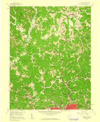 1958 Pocatalico1960 Print · USGSThe northern hills of Charleston appear in the late fifties as a mix of traditional mining and new suburban growth. Researchers can trace family roots through numerous country schools and churches like Aetna Dell Sch, Bias Chapel, and the Tyler Mtn Memory Gardens.4 unique versions available
 - 1958 Map of Charleston East, 1978 Print
 1958 Charleston East1978 Print · USGSThe industrial corridor of the Kanawha River valley east of Charleston is captured here in the late fifties, showcasing a landscape defined by manufacturing and transit. Genealogists and local researchers can trace family names and community landmarks from Spring Hill Cemetery to Dupont City and Hess Cem.
End of results
Showing maps 1-8 of 8
Top cities near Charleston
- South Charleston historical maps
- St. Albans historical maps
- Saint Albans historical maps
- Dunbar historical maps
- Winfield historical maps
- Marmet historical maps
See more
Top neighborhoods of Charleston
- Airport Village historical maps
- Hillsdale historical maps
- Ivydale historical maps
- North Charleston historical maps
- East Side historical maps
- Oakwood historical maps
See more
Frequently asked questions
- What are the different types of historical maps available for Charleston?
- What is the oldest map of Charleston?
- Where can I purchase historical maps of Charleston for my home or office?
- Where can I download high-res historical maps of Charleston?
- Are there historical topographic maps available for Charleston?
- Is there historical aerial imagery available for Charleston?
- Where are historical maps of Charleston sourced from?