1970s Maps of Crown Hill, West Virginia
Explore 1 historic maps of Crown Hill from the 1970s. These maps offer a rare glimpse into what life looked like during the 1970s — showing old roads, neighborhoods, homes, and landmarks that have changed or disappeared over time.
Whether you're researching your family's past, planning a metal detecting trip, or studying how Crown Hill's landscape evolved across the 1970s, these high-resolution maps are a powerful tool for exploring the history of this region.
- Focus on a specific era: All maps on this page are from the 1970s, giving you a focused view of this time period.
- See what’s changed: Compare century-old streets, trails, and buildings to today's modern landscape using overlays and satellite layers.
- Research with precision: Use these maps for genealogy, historical research, land use analysis, or educational projects.
- View, download, or print: Maps are fully viewable online in high resolution, and can be downloaded or printed for your own records.
Start exploring Crown Hill's history through authentic maps from the 1970s. This is your window into the past.
Crown Hill, WV maps
(1)- 1977 Map of Cedar Grove, 1980 Print
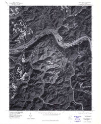 1977 Cedar Grove1980 Print · USGSThe Kanawha River valley of the late seventies is captured here in sharp photographic detail. Researchers can trace the layout of riverside settlements like Cedar Grove and Chelyan or follow the hollows to Dry Branch and Miami.
End of results
Showing maps 1-1 of 1
Top cities near Crown Hill
- Charleston historical maps
- Montgomery historical maps
- Marmet historical maps
- Chesapeake historical maps
- Rand historical maps
- Belle historical maps
See more
Frequently asked questions
- What are the different types of historical maps available for Crown Hill?
- What is the oldest map of Crown Hill?
- Where can I purchase historical maps of Crown Hill for my home or office?
- Where can I download high-res historical maps of Crown Hill?
- Are there historical topographic maps available for Crown Hill?
- Is there historical aerial imagery available for Crown Hill?
- Where are historical maps of Crown Hill sourced from?