1960s Maps of Lewis County, West Virginia
Explore 16 historic maps of Lewis County from the 1960s. These maps offer a rare glimpse into what life looked like during the 1960s — showing old roads, neighborhoods, homes, and landmarks that have changed or disappeared over time.
Whether you're researching your family's past, planning a metal detecting trip, or studying how Lewis County's landscape evolved across the 1960s, these high-resolution maps are a powerful tool for exploring the history of this region.
- Focus on a specific era: All maps on this page are from the 1960s, giving you a focused view of this time period.
- See what’s changed: Compare century-old streets, trails, and buildings to today's modern landscape using overlays and satellite layers.
- Research with precision: Use these maps for genealogy, historical research, land use analysis, or educational projects.
- View, download, or print: Maps are fully viewable online in high resolution, and can be downloaded or printed for your own records.
Start exploring Lewis County's history through authentic maps from the 1960s. This is your window into the past.
Lewis County, WV maps
(16)- 1961 Map of Clarksburg
 1961 Clarksburg1961 Print · USGSThe mid-century industrial and river landscapes of West Virginia and Ohio are detailed here, centered on the Ohio River. Researchers can trace the Baltimore and Ohio rail lines connecting towns like Parkersburg, Clarksburg, and Monongah.
 - 1961 Map of Charleston
 1961 Charleston1961 Print · USGSWest Virginia's capital region and the highlands to the east are shown in detail during the early sixties. Genealogists and historians can trace rail networks like the Baltimore and Ohio RR and find early state parks such as Watoga State Park.
 - 1961 Map of Berlin, 1962 Print
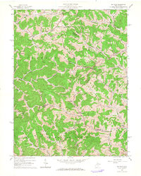
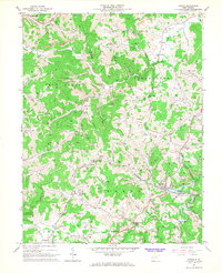
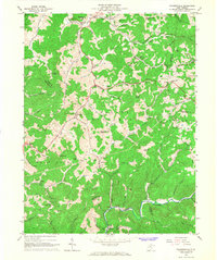
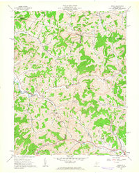 1961 Berlin1962 Print · USGSWest Virginia's Lewis County uplands come alive in this early 1960s survey, showing the deep-cut valleys and ridgeline settlements of the era. Genealogists and historians can trace family locations near Berlin, the Reger Cem, and rural centers like the Buckhannon Run Ch.2 unique versions available
 - 1961 Map of Weston, 1962 Print
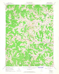
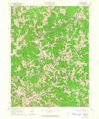
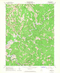
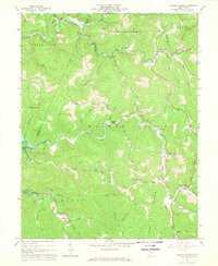
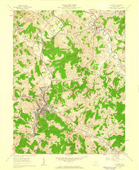 1961 Weston1962 Print · USGSWeston and the West Fork River valley are captured here in the early sixties as the regional rail economy and local industry shaped the hills of Lewis County. Researchers can locate family landmarks like Jackson Mill, the sprawling Weston State Hospital, and country burials such as Bush Cem.3 unique versions available
 - 1961 Map of West Milford, 1962 Print
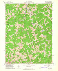
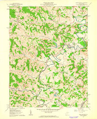 1961 West Milford1962 Print · USGSHarrison and Lewis Counties come alive in the early sixties as a landscape of river valleys and ridgeline industry. Genealogists and historians can trace family locations near West Milford, the Kobergard Sch, or the many Strip Mines and Oil Wells that defined the era.2 unique versions available
 - 1964 Map of Camden, 1965 Print
 1964 Camden1965 Print · USGSLewis County in the early sixties reveals a landscape shaped by narrow creek valleys and the reach of the local coal and gas industries. Researchers can trace rural lineages through sites like Mt Morris Ch, Pricetown, and the Middle Run Cem along the waters of Leading Creek.2 unique versions available
 - 1964 Map of Big Isaac, 1966 Print
 1964 Big Isaac1966 Print · USGSHarrison and Doddridge counties were centers of rural industry in the mid-1960s, defined by the gas and oil economy. Researchers can trace family sites near Big Isaac and Kincheloe or locate community centers like Morris Chapel and Greenbrier Sch.2 unique versions available
 - 1964 Map of Vadis, 1966 Print
 1964 Vadis1966 Print · USGSWest Virginia's rural Lewis and Gilmer County borderlands are shown here in the mid-1960s as the local economy revolved around active extraction and creek-bottom farming. Researchers can locate numerous country churches and cemeteries like Doyle Chapel, Rock Grove Ch, and Liberty Cem.2 unique versions available
 - 1965 Map of New Milton, 1966 Print
 1965 New Milton1966 Print · USGSIn the mid-1960s, the rural valleys of Doddridge County were defined by a dense network of homesteads and natural resource extraction. Genealogists can locate family landmarks such as Locust Grove Ch, Childers Cem, and the community of New Milton along the winding Meathouse Fork.2 unique versions available
 - 1965 Map of Orlando, 1967 Print
 1965 Orlando1967 Print · USGSCentral West Virginia's river valleys and rail lines come alive in the mid-1960s as the Little Kanawha River snakes past small settlements and timbered ridges. Genealogists and local historians can locate many rural landmarks, including St Michaels Ch, Falls Mill, and the Ratcliff Sch.3 unique versions available
 - 1966 Map of Adrian, 1967 Print
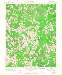
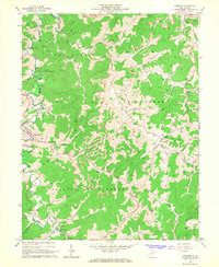
 1966 Adrian1967 Print · USGSIn the mid-1960s, this area of Upshur and Lewis counties centered on the Baltimore and Ohio rail line and the gas-producing hills of Skin Creek. Genealogists and historians can trace numerous family-named landmarks, from Collins Settlement and McCue Town to country churches like Reger Chapel.2 unique versions available
 - 1966 Map of Gilmer, 1968 Print
 1966 Gilmer1968 Print · USGSThe mid-1960s central West Virginia hills are captured here, centered on the river and rail lines that sustained local industry. Genealogists can trace family landmarks and rural congregations like Hiney Ch, Stouts Mills, and Edmiston Cem.2 unique versions available
 - 1966 Map of Roanoke, 1968 Print
 1966 Roanoke1968 Print · USGSCentral West Virginia's river valleys and ridgelines are captured here in the 1960s, showing the rural character of Lewis and Upshur Counties. Researchers can locate family landmarks such as Alkires Mills, trace the Baltimore and Ohio Railroad, and find remote burial sites like Rockford-Pletcher Cem.3 unique versions available
 - 1966 Map of Peterson, 1968 Print
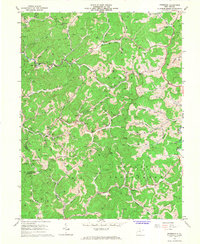 1966 Peterson1968 Print · USGSLewis County hill country is captured here in the mid-sixties, showing a landscape defined by isolated farmsteads and narrow creek valleys. Genealogists can trace family roots through Collins Settlement and landmarks like St Bernards Ch and Bealls Mills.3 unique versions available
 - 1966 Map of Walkersville, 1968 Print
 1966 Walkersville1968 Print · USGSIn the mid-1960s, these West Virginia hills were a patchwork of small communities like Ireland and Walkersville connected by the Baltimore and Ohio railroad. Researchers can trace local history at the Fort Pickens Monument or locate family roots at Heading Chapel and Long Point Cem.2 unique versions available
 - 1967 Map of Hacker Valley, 1968 Print
 1967 Hacker Valley1968 Print · USGSHacker Valley and the surrounding Webster County hills appear in the late 1960s just as the Sutton Lake project influenced the drainage. Local historians can trace family locations near Chestnut Grove Ch, the settlement of Cleveland, and landmarks like Courthouse Rock.2 unique versions available
End of results
Showing maps 1-16 of 16
Top cities of Lewis County
Frequently asked questions
- What are the different types of historical maps available for Lewis County?
- What is the oldest map of Lewis County?
- Where can I purchase historical maps of Lewis County for my home or office?
- Where can I download high-res historical maps of Lewis County?
- Are there historical topographic maps available for Lewis County?
- Is there historical aerial imagery available for Lewis County?
- Where are historical maps of Lewis County sourced from?