1960s Maps of Jacksonville, West Virginia
Explore 2 historic maps of Jacksonville from the 1960s. These maps offer a rare glimpse into what life looked like during the 1960s — showing old roads, neighborhoods, homes, and landmarks that have changed or disappeared over time.
Whether you're researching your family's past, planning a metal detecting trip, or studying how Jacksonville's landscape evolved across the 1960s, these high-resolution maps are a powerful tool for exploring the history of this region.
- Focus on a specific era: All maps on this page are from the 1960s, giving you a focused view of this time period.
- See what’s changed: Compare century-old streets, trails, and buildings to today's modern landscape using overlays and satellite layers.
- Research with precision: Use these maps for genealogy, historical research, land use analysis, or educational projects.
- View, download, or print: Maps are fully viewable online in high resolution, and can be downloaded or printed for your own records.
Start exploring Jacksonville's history through authentic maps from the 1960s. This is your window into the past.
Jacksonville, WV maps
(2)- 1961 Map of Charleston
 1961 Charleston1961 Print · USGSWest Virginia's capital region and the highlands to the east are shown in detail during the early sixties. Genealogists and historians can trace rail networks like the Baltimore and Ohio RR and find early state parks such as Watoga State Park.
 - 1966 Map of Roanoke, 1968 Print
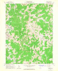 1966 Roanoke1968 Print · USGSCentral West Virginia's river valleys and ridgelines are captured here in the 1960s, showing the rural character of Lewis and Upshur Counties. Researchers can locate family landmarks such as Alkires Mills, trace the Baltimore and Ohio Railroad, and find remote burial sites like Rockford-Pletcher Cem.3 unique versions available
End of results
Showing maps 1-2 of 2
Top cities near Jacksonville
- Buckhannon historical maps
- Weston historical maps
- Sutton historical maps
- Burnsville historical maps
- Jane Lew historical maps
- Flatwoods historical maps
Frequently asked questions
- What are the different types of historical maps available for Jacksonville?
- What is the oldest map of Jacksonville?
- Where can I purchase historical maps of Jacksonville for my home or office?
- Where can I download high-res historical maps of Jacksonville?
- Are there historical topographic maps available for Jacksonville?
- Is there historical aerial imagery available for Jacksonville?
- Where are historical maps of Jacksonville sourced from?