1920s Maps of Vadis, West Virginia
Explore 2 historic maps of Vadis from the 1920s. These maps offer a rare glimpse into what life looked like during the 1920s — showing old roads, neighborhoods, homes, and landmarks that have changed or disappeared over time.
Whether you're researching your family's past, planning a metal detecting trip, or studying how Vadis's landscape evolved across the 1920s, these high-resolution maps are a powerful tool for exploring the history of this region.
- Focus on a specific era: All maps on this page are from the 1920s, giving you a focused view of this time period.
- See what’s changed: Compare century-old streets, trails, and buildings to today's modern landscape using overlays and satellite layers.
- Research with precision: Use these maps for genealogy, historical research, land use analysis, or educational projects.
- View, download, or print: Maps are fully viewable online in high resolution, and can be downloaded or printed for your own records.
Start exploring Vadis's history through authentic maps from the 1920s. This is your window into the past.
Vadis, WV maps
(2)- 1925 Map of Vadis, 1981 Print
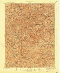
 1925 Vadis1981 Print · USGSCentral West Virginia's highlands in the mid-twenties reveal a landscape of hollows and ridges dotted with one-room schoolhouses and country parishes. Genealogists can trace family roots through numerous sites like St Marys Church, Vadis, and Lower Walnut School.
 - 1927 Map of Vadis
 1927 Vadis1927 Print · USGSWest Virginia's central highlands are shown here in the mid-1920s, a landscape defined by isolated farmsteads and valley-bottom settlements. Genealogists and historians can trace dozens of rural school sites and landmarks like St Boniface Church, Alum Bridge, and Freemansburg.2 unique versions available
End of results
Showing maps 1-2 of 2
Top cities near Vadis
- Weston historical maps
- Glenville historical maps
- Burnsville historical maps
- Sand Fork historical maps
- Auburn historical maps
Frequently asked questions
- What are the different types of historical maps available for Vadis?
- What is the oldest map of Vadis?
- Where can I purchase historical maps of Vadis for my home or office?
- Where can I download high-res historical maps of Vadis?
- Are there historical topographic maps available for Vadis?
- Is there historical aerial imagery available for Vadis?
- Where are historical maps of Vadis sourced from?